Bebauungspläne und Flächennutzungspläne der saarländischen Kommunen
Ein Bebauungsplan regelt, was, wo und wieviel auf einem Grundstück gebaut werden darf. Er ist ein wichtiges Instrument für die städtebauliche Ordnung und Entwicklung einer Gemeinde oder einer Stadt.
Die Bereitstellung digitaler kommunaler Pläne und Satzungen wird durch gesetzliche Vorgaben auf europäischer und saarländischer Ebene unterstützt und gefordert (INSPIRE-Richtlinie, SGDIG).
Die Fachanwendung im GeoPortal Saarland ermöglicht die Darstellung der Bebauungspläne der Kommunen gegliedert nach Gemeindeteilen. Der Nutzer kann sich neben der Kartenansicht auch die textlichen Festsetzungen und zusätzliche Metadateninformationen abrufen und ausdrucken.
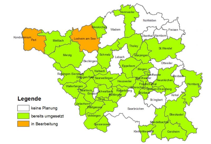
Derzeit ist noch keine vollständige Abdeckung aller Gemeinden im Saarland gegeben (vgl. Abbildung). Zudem stellen die Daten im GeoPortal keine amtliche und/oder rechtsverbindliche Auskunft dar und erheben nicht den Anspruch auf Vollständigkeit. Rechtlich verbindlich sind ausschließlich die genehmigten Originalkarten, die bei den Städten und Gemeinden eingesehen werden können.
Neben den Bebauungsplänen werden im Geoportal Saarland auch Flächennutzungspläne der Gemeinden sowie der Flächennutzungsplan des Regionalverbandes Saarbrücken dargestellt.
Downloads

</translate>