Nationalpark Hunsrueck Hochwald/en: Unterschied zwischen den Versionen
(Übernehme Bearbeitung einer neuen Version der Quellseite) |
Tschug (Diskussion | Beiträge) K |
||
| (26 dazwischenliegende Versionen von 2 Benutzern werden nicht angezeigt) | |||
| Zeile 1: | Zeile 1: | ||
__NOTOC__ |
__NOTOC__ |
||
| ⚫ | |||
| ⚫ | |||
| − | <div class="mw-translate-fuzzy"> |
||
| + | |||
| ⚫ | |||
| − | [[File: |
+ | <p> [[File:hunnenring.jpg|alt=Hun Ring|x282px|link=//{{SERVERNAME}}/mapbender/frames/index.php?lang=de&gui_id=Geoportal-SL-2020&WMC=3211]] |
| ⚫ | |||
</p> |
</p> |
||
| − | '' |
+ | ''Photo: K. Funk'' |
| ⚫ | |||
== Viewer == |
== Viewer == |
||
| − | <p><strong>[//{{SERVERNAME}}/mapbender/frames/index.php?lang=de&gui_id=Geoportal-SL-2020&WMC=3211 |
+ | <p><strong>[//{{SERVERNAME}}/mapbender/frames/index.php?lang=de&gui_id=Geoportal-SL-2020&WMC=3211 Go to map service ‘ Hunsrück-Hochwald National Park (Saarland section)’]</strong><br /> |
| − | <strong>[//{{SERVERNAME}}/mapbender/frames/index.php?lang=de&gui_id=Geoportal-SL-2020&WMC=3907 |
+ | <strong>[//{{SERVERNAME}}/mapbender/frames/index.php?lang=de&gui_id=Geoportal-SL-2020&WMC=3907 Go to map service ‘Hunsrück-Hochwald National Park (total area)’]</strong></p> |
| + | == Description == |
||
| − | <div class="mw-translate-fuzzy"> |
||
| + | <p>Rhineland-Palatinate and Saarland have signed a state charter to create a transboundary national park covering a total area of roughly 10,000 ha within the two states. The corresponding legislation was passed by the state parliaments of Saarland and Rhineland-Palatinate in late 2014/early 2015. Around 985 ha of the national park lies within the boundaries of the local government areas of Nohfelden and Nonnweiler. This region, which is located in Saarland, is shown on a topographic 1:10,000 scale map and a boundary 1:2,000 scale map (split over 8 sheets).</p> |
||
| − | == Beschreibung == |
||
| − | <p>Rheinland–Pfalz und das Saarland haben durch einen Staatsvertrag einen gemeinsamen Ländergrenzen überschreitenden Nationalpark in einer Gesamtgröße von ca. 10.000 ha eingerichtet. Die entsprechenden Gesetze wurden durch die Landtage des Saarlandes und des Landes Rheinland-Pfalz Ende 2014 bzw. Anfang 2015 verabschiedet. Rund 985 Hektar des Nationalparks liegen innerhalb des Gebietes der Gemeinden Nohfelden und Nonnweiler. Dieses im Saarland liegende Teilgebiet ist in einer Gliederungskarte im Maßstab 1: 10.000 und einer Grenzkarte (in 8 Blattschnitten) im Maßstab 1: 2.000 dargestellt.<br /><br /> |
||
| + | <p>The thematic map shows the area that is valid for subsidiary protection as a national park in Saarland pursuant to section 24 of the Federal Conservation Act. This area is subdivided into the nature zone, consisting of nature zone 1a (untouched areas, dark green) and nature zone 1b (development areas, light green). This colour coding is intended to represent the varying level of man-made intervention in these two areas. In nature zone 1a (untouched areas), all forest management work has been discontinued and the forest has been left to its own devices. In nature zone 1b (development areas), the aim is to remove non-native species (and especially conifers) and thereby reconfigure the forest so that nature can take over and develop communities of forest species that are typical for the region. Overall, a maximum time frame of 30 years is allowed for nature zone 1b to develop into nature zone 1a.</p> |
||
| − | Aus der Grenzkarte ist das Gebiet zu ersehen, für das die Unterschutzstellung als Nationalpark nach § 24 BNatSchG im Saarland gültig ist. Dieses Gebiet ist untergliedert in die Naturzone, die sich in eine Naturzone 1a (Wildnisbereiche, dunkelgrün) und eine Naturzone 1b (Entwicklungsbereiche, hellgrün) unterteilt. Diese unterschiedliche Farbgebung soll sozusagen den unterschiedlichen „Wildnisgrad“ dieser beiden Gebiete widergeben. In der Naturzone 1a (Wildnisbereiche) ist der Wald bereits vollständig aus der forstlichen Bewirtschaftung genommen und sich selbst überlassen. In der Naturzone 1b (Entwicklungsbereiche) soll der Wald durch Entnahme der nicht standortheimischen Arten (insbesondere Nadelbäume) noch so umgebaut werden, dass sich die von Natur aus standorttypischen Waldgesellschaften dort einstellen können. Insgesamt ist ein maximaler Zeitrahmen von 30 Jahren gegeben, damit sich die Naturzone 1b in die Naturzone 1a entwickeln kann.<br /><br /> |
||
| + | <p>Ultimately, nature zone 1a will then cover 75 percent of the park’s total area, so as to meet the IUCN’s international criteria for national parks. Nature will then be left to itself in this area.<br /> |
||
| − | Die Naturzone 1a soll dann 75% der Gesamtfläche des Nationalparks ausmachen, um die internationalen Kriterien der IUCN für Nationalparks zu erfüllen. Auf dieser Fläche darf Natur dann Natur sein.<br /> |
||
| + | The remaining area, making up 25 percent of the park, is assigned to buffer zone 2. This zone is intended to protect the nature zone against negative impacts from neighbouring territories. In this zone, upkeep and development measures can be carried out, which can also include supplying local populations with firewood, for example. Since the boundary map and the corresponding map service allow the identification of individual cadastral parcels, landowners can determine the exact extent – if any – to which they are affected by this project.</p> |
||
| − | Die restliche Fläche mit ihrem Anteil von rund 25 % ist der Pflegezone 2 zugeordnet. Diese soll die Naturzone vor negativen Einflüssen aus den benachbarten Gebieten schützen. In dieser Zone ist die Durchführung von Pflege- und Entwicklungsmaßnahmen, die auch der Versorgung der Bürgerinnen und Bürger mit Brennholz dienen, möglich möglich. Da in der Grenzkarte und dem entsprechenden Kartendienst die jeweiligen Flurstücke zu identifizieren sind, können Eigentümerinnen und Eigentümer genau feststellen, ob und gegebenenfalls inwieweit sie durch das Vorhaben betroffen sind.</p> |
||
| − | <p> |
+ | <p>The boundary map and thematic map are fundamental to the creation of the Hunsrück-Hochwald National Park (Saarland section).</p> |
| − | </div> |
||
| − | + | <p>Relevant legislation for the Hunsrück-Hochwald National Park includes the following:</p> |
|
<ul> |
<ul> |
||
| − | <li> |
+ | <li>the '''Act of Ratification for the State Charter between the States of Rhineland-Palatinate and Saarland Concerning the Creation and Maintenance of Hunsrück-Hochwald National Park'''</li> |
| − | <li>''' |
+ | <li>'''the State Charter between the States of Rhineland-Palatinate and Saarland Concerning the Creation and Maintenance of Hunsrück-Hochwald National Park'''</li> |
| − | <li> |
+ | <li>the '''topographic map''' and</li> |
| − | <li> |
+ | <li>the '''boundary map''' for the Hunsrück-Hochwald National Park</li> |
</ul> |
</ul> |
||
| + | <p>Saarland’s Act of Ratification for the State Charter between the States of Rhineland-Palatinate and Saarland Concerning the Creation and Maintenance of Hunsrück-Hochwald National Park can be viewed here ( |
||
| − | Das saarländische Gesetz über die Zustimmung zu dem Staatsvertrag zwischen den Ländern Rheinland-Pfalz und Saarland über die Errichtung und Unterhaltung des Nationalparks Hunsrück-Hochwald kann hier ( |
||
| − | [//{{SERVERNAME}}/mediawiki/images/d/df/Nationalpark_gesetz.pdf |
+ | [//{{SERVERNAME}}/mediawiki/images/d/df/Nationalpark_gesetz.pdf State Charter]).</p> |
| + | |||
| − | </p> |
||
| + | <p>'''Hunsrück-Hochwald National Park'''<br /> |
||
| + | The transboundary Hunsrück-Hochwald National Park offers a unique natural environment, characterised by ancient beech woods, secluded moorlands, vibrant forest floors, stony outcrops and resplendent fields of arnica. ‘Letting nature be itself’ is the Park’s motto. What is meant by this are the natural processes that we humans consciously do not change or interrupt. The wide spaces of a national park are perfect for this kind of development.<br /> |
||
| + | While the Saarland section makes up only a tenth of the total area, it is certainly not without its charms. The monumental ring wall is a striking relic of our ancient Celtic ancestors and is particularly popular with Park visitors. The Eisener Forest is an area of outstanding natural beauty and, as a Special Area of Conservation and bird sanctuary, forms part of the European Natura 2000 system of protected sites.<br /> |
||
| + | Anyone visiting the national park cannot fail to notice three literal ‘highlights’: |
||
| + | <ul style="margin-top: -0.65em; margin-bottom: -0.65em;"> |
||
| + | <li>The Erbeskopf, the highest point of elevation in Rhineland-Palatinate, with the Hunsrückhaus Visitor Centre.</li> |
||
| + | <li>The Wildenburg, with its fairy-tale crags and forests plus a local game preserve.</li> |
||
| + | <li>The ‘Ring of the Huns’ and Celtic village in Otzenhausen (Saarland) at the foot of the Dollberg bring the Celts and their history to life.</li> |
||
| ⚫ | |||
| + | A reception and information area for visitors is provided at three National Park Gatehouses (in Saarland: Otzenhausen Celtic Park).</p> |
||
== Downloads == |
== Downloads == |
||
| − | === |
+ | === Topographic map === |
| − | + | This is a 1: 10,000 scale map that provides an initial overview of the external border and internal structure of Hunsrück-Hochwald National Park. |
|
| − | <p>[[File:Gliederungskarte_neu2.jpg|alt= |
+ | <p>[[File:Gliederungskarte_neu2.jpg|alt=Topographic map|600px|link=]]</p> |
<ul class="box" style="margin-top: 0px;"> |
<ul class="box" style="margin-top: 0px;"> |
||
| − | <li class="download">[//{{SERVERNAME}}/mediawiki/images/7/7b/Gliederungskarte_Saar.pdf Download |
+ | <li class="download">[//{{SERVERNAME}}/mediawiki/images/7/7b/Gliederungskarte_Saar.pdf Download ‘Topographic map’]</li> |
</ul> |
</ul> |
||
| + | The 1: 2,000 boundary map and the corresponding map service can be used to clearly locate and identify the respective cadastral parcels in terms of their location within the National Park. The division of this map into separate sheets is intended to help with orientation and help with map searches. |
||
| − | Aus der Grenzkarte im Maßstab 1: 2.000 und dem entsprechenden Kartendienst können die jeweiligen Flurstücke hinsichtlich ihrer Lage im Nationalpark eindeutig verortet und identifiziert werden. Die Blattschnittübersicht soll die Orientierung erleichtern und einen geeigneten Suchhinweis liefern. |
||
| − | === |
+ | === Map sheet overview === |
| − | <p>[[File:blattuebersicht_neu2.jpg|alt= |
+ | <p>[[File:blattuebersicht_neu2.jpg|alt=Map sheet overview|600px|link=]]</p> |
<ul class="box" style="margin-top: 0px;"> |
<ul class="box" style="margin-top: 0px;"> |
||
| − | <li class="download">[//{{SERVERNAME}}/mediawiki/images/c/c1/Blattschnittuebersicht_i.pdf Download |
+ | <li class="download">[//{{SERVERNAME}}/mediawiki/images/c/c1/Blattschnittuebersicht_i.pdf Download ‘Map sheet overview’]</li> |
| − | <li class="download">[//{{SERVERNAME}}/mediawiki/images/4/4f/Grenzkarte_Blatt_1.pdf Download |
+ | <li class="download">[//{{SERVERNAME}}/mediawiki/images/4/4f/Grenzkarte_Blatt_1.pdf Download sheet 1]</li> |
| − | <li class="download">[//{{SERVERNAME}}/mediawiki/images/6/61/Grenzkarte_Blatt_2.pdf Download |
+ | <li class="download">[//{{SERVERNAME}}/mediawiki/images/6/61/Grenzkarte_Blatt_2.pdf Download sheet 2]</li> |
| − | <li class="download">[//{{SERVERNAME}}/mediawiki/images/c/c0/Grenzkarte_Blatt_3.pdf Download |
+ | <li class="download">[//{{SERVERNAME}}/mediawiki/images/c/c0/Grenzkarte_Blatt_3.pdf Download sheet 3]</li> |
| − | <li class="download">[//{{SERVERNAME}}/mediawiki/images/3/36/Grenzkarte_Blatt_4.pdf Download |
+ | <li class="download">[//{{SERVERNAME}}/mediawiki/images/3/36/Grenzkarte_Blatt_4.pdf Download sheet 4]</li> |
| − | <li class="download">[//{{SERVERNAME}}/mediawiki/images/a/ac/Grenzkarte_Blatt_5.pdf Download |
+ | <li class="download">[//{{SERVERNAME}}/mediawiki/images/a/ac/Grenzkarte_Blatt_5.pdf Download sheet 5]</li> |
| − | <li class="download">[//{{SERVERNAME}}/mediawiki/images/a/a4/Grenzkarte_Blatt_6.pdf Download |
+ | <li class="download">[//{{SERVERNAME}}/mediawiki/images/a/a4/Grenzkarte_Blatt_6.pdf Download sheet 6]</li> |
| − | <li class="download">[//{{SERVERNAME}}/mediawiki/images/2/2d/Grenzkarte_Blatt_7.pdf Download |
+ | <li class="download">[//{{SERVERNAME}}/mediawiki/images/2/2d/Grenzkarte_Blatt_7.pdf Download sheet 7]</li> |
| − | <li class="download">[//{{SERVERNAME}}/mediawiki/images/3/3a/Grenzkarte_Blatt_8.pdf Download |
+ | <li class="download">[//{{SERVERNAME}}/mediawiki/images/3/3a/Grenzkarte_Blatt_8.pdf Download sheet 8]</li> |
</ul> |
</ul> |
||
| − | == |
+ | == Contacts == |
| + | '''Ministry for the Environment, Climate, Mobility, Agriculture and Consumer Protection'''<br /> |
||
| − | '''Ministerium für Umwelt und Verbraucherschutz'''<br /> |
||
| − | + | Dept. D/3 Agriculture and Fishing<br /> |
|
| − | Dr. |
+ | Dr. Tanja Helmes<br /> |
| − | [mailto: |
+ | [mailto:t.helmes@umwelt.saarland.de Email]<br /> |
| + | Phone: +49 681 501-4355 |
||
Aktuelle Version vom 2. Januar 2023, 08:35 Uhr
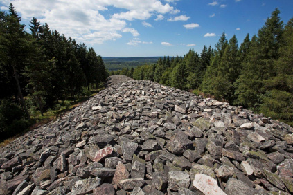
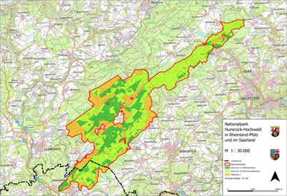
Hunsrück–Hochwald National Park in Rhineland-Palatinate and Saarland (February 2015)
Photo: K. Funk
Viewer
Go to map service ‘ Hunsrück-Hochwald National Park (Saarland section)’
Go to map service ‘Hunsrück-Hochwald National Park (total area)’
Description
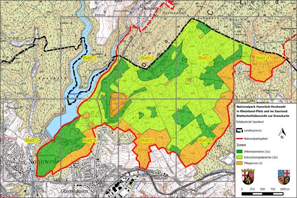
Rhineland-Palatinate and Saarland have signed a state charter to create a transboundary national park covering a total area of roughly 10,000 ha within the two states. The corresponding legislation was passed by the state parliaments of Saarland and Rhineland-Palatinate in late 2014/early 2015. Around 985 ha of the national park lies within the boundaries of the local government areas of Nohfelden and Nonnweiler. This region, which is located in Saarland, is shown on a topographic 1:10,000 scale map and a boundary 1:2,000 scale map (split over 8 sheets).
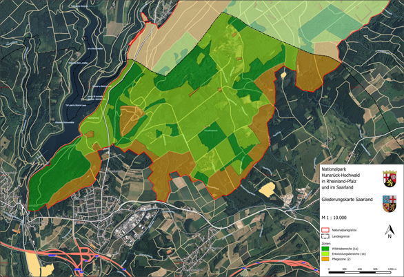
The thematic map shows the area that is valid for subsidiary protection as a national park in Saarland pursuant to section 24 of the Federal Conservation Act. This area is subdivided into the nature zone, consisting of nature zone 1a (untouched areas, dark green) and nature zone 1b (development areas, light green). This colour coding is intended to represent the varying level of man-made intervention in these two areas. In nature zone 1a (untouched areas), all forest management work has been discontinued and the forest has been left to its own devices. In nature zone 1b (development areas), the aim is to remove non-native species (and especially conifers) and thereby reconfigure the forest so that nature can take over and develop communities of forest species that are typical for the region. Overall, a maximum time frame of 30 years is allowed for nature zone 1b to develop into nature zone 1a.
Ultimately, nature zone 1a will then cover 75 percent of the park’s total area, so as to meet the IUCN’s international criteria for national parks. Nature will then be left to itself in this area.
The remaining area, making up 25 percent of the park, is assigned to buffer zone 2. This zone is intended to protect the nature zone against negative impacts from neighbouring territories. In this zone, upkeep and development measures can be carried out, which can also include supplying local populations with firewood, for example. Since the boundary map and the corresponding map service allow the identification of individual cadastral parcels, landowners can determine the exact extent – if any – to which they are affected by this project.
The boundary map and thematic map are fundamental to the creation of the Hunsrück-Hochwald National Park (Saarland section).
Relevant legislation for the Hunsrück-Hochwald National Park includes the following:
- the Act of Ratification for the State Charter between the States of Rhineland-Palatinate and Saarland Concerning the Creation and Maintenance of Hunsrück-Hochwald National Park
- the State Charter between the States of Rhineland-Palatinate and Saarland Concerning the Creation and Maintenance of Hunsrück-Hochwald National Park
- the topographic map and
- the boundary map for the Hunsrück-Hochwald National Park
Saarland’s Act of Ratification for the State Charter between the States of Rhineland-Palatinate and Saarland Concerning the Creation and Maintenance of Hunsrück-Hochwald National Park can be viewed here ( State Charter).
Hunsrück-Hochwald National Park
The transboundary Hunsrück-Hochwald National Park offers a unique natural environment, characterised by ancient beech woods, secluded moorlands, vibrant forest floors, stony outcrops and resplendent fields of arnica. ‘Letting nature be itself’ is the Park’s motto. What is meant by this are the natural processes that we humans consciously do not change or interrupt. The wide spaces of a national park are perfect for this kind of development.
While the Saarland section makes up only a tenth of the total area, it is certainly not without its charms. The monumental ring wall is a striking relic of our ancient Celtic ancestors and is particularly popular with Park visitors. The Eisener Forest is an area of outstanding natural beauty and, as a Special Area of Conservation and bird sanctuary, forms part of the European Natura 2000 system of protected sites.
Anyone visiting the national park cannot fail to notice three literal ‘highlights’:
- The Erbeskopf, the highest point of elevation in Rhineland-Palatinate, with the Hunsrückhaus Visitor Centre.
- The Wildenburg, with its fairy-tale crags and forests plus a local game preserve.
- The ‘Ring of the Huns’ and Celtic village in Otzenhausen (Saarland) at the foot of the Dollberg bring the Celts and their history to life.
A reception and information area for visitors is provided at three National Park Gatehouses (in Saarland: Otzenhausen Celtic Park).
Downloads
Topographic map
This is a 1: 10,000 scale map that provides an initial overview of the external border and internal structure of Hunsrück-Hochwald National Park.

The 1: 2,000 boundary map and the corresponding map service can be used to clearly locate and identify the respective cadastral parcels in terms of their location within the National Park. The division of this map into separate sheets is intended to help with orientation and help with map searches.
Map sheet overview

- Download ‘Map sheet overview’
- Download sheet 1
- Download sheet 2
- Download sheet 3
- Download sheet 4
- Download sheet 5
- Download sheet 6
- Download sheet 7
- Download sheet 8
Contacts
Ministry for the Environment, Climate, Mobility, Agriculture and Consumer Protection
Dept. D/3 Agriculture and Fishing
Dr. Tanja Helmes
Email
Phone: +49 681 501-4355

