Bodenrichtwerte/en: Unterschied zwischen den Versionen
Tharth (Diskussion | Beiträge) |
Tschug (Diskussion | Beiträge) K |
||
| (50 dazwischenliegende Versionen von 4 Benutzern werden nicht angezeigt) | |||
| Zeile 1: | Zeile 1: | ||
__NOTOC__ |
__NOTOC__ |
||
| − | == BORIS Saarland (Stand 2016) == |
||
| ⚫ | |||
| + | === <p style="color: red;">Hinweis zur Grundsteuerreform</p> === |
||
| ⚫ | |||
| + | <p style="color: red;">Wenn Sie den Bodenrichtwert Ihres Grundstücks zur Erstellung der <strong>Feststellungserklärung für den Grundsteuerwert</strong> (Hauptfeststellung im Rahmen der Grundsteuerreform) abfragen wollen, wählen Sie bitte die Anwendung <strong>„Bodenrichtwerte für Grundsteuerzwecke“</strong> aus.<br /> |
||
| − | <div class="mw-translate-fuzzy"> |
||
| + | <br /> |
||
| ⚫ | |||
| + | <strong>Bitte geben Sie ausschließlich die Werte aus der Anwendung „Bodenrichtwerte für Grundsteuerzwecke“ in Ihrer Feststellungserklärung an.</strong></p> |
||
| ⚫ | |||
| + | {| style="width: 80%; vertical-align:top; text-align: left;" |
||
| − | <p>Die Bodenrichtwerte stehen saarlandweit und fast flächendeckend online zur Verfügung. |
||
| + | |width="40%"|<h2> BORIS Saarland (last updated 2024) </h2> |
||
| − | BORIS Saarland ist ein Bodenrichtwertinformationssystem, welches einen Basisdienst für gebührenfreie Online-Recherche bietet. |
||
| + | |style="width: 10%"| |
||
| − | Für eine Suche stehen Ihnen die Möglichkeit einer Adresssuche (Gemeinde, Straße) oder einer Flurstückssuche (Gemarkung, Flur, Flurstück) zur Verfügung. Mit Hilfe von BORIS Saarland können Sie Informationen über die Bodenrichtwertzonen erhalten.</p> |
||
| + | |width="40%"|<h2> Bodenrichtwerte für Grundsteuerzwecke </h2> |
||
| − | <p>Über einen Klick auf den Button [[Datei:Mapbender-Info-Icon.jpg|link=|frameless|alt="Mapbender Info Symbol"|31px]] Datenabfrage und einem anschließenden Klick in die „Karte“ erhalten Sie ein Info-Fenster, in dem die Gemeinde, die Gemarkung, die Bodenrichtwertzonennummer, der Bodenrichtwert in €/m², der Stichtag, die Nutzungsart, die wertbeeinflussenden Merkmale und der zuständige Gutachterausschuss für Grundstückswerte erscheint. |
||
| + | |- |
||
| − | Umrechnungskoeffizienten zu den wertbeeinflussenden Merkmalen können bei den jeweiligen Gutachterausschüssen kostenpflichtig angefordert werden. Ebenso kann beim Gutachterausschuss nach wie vor eine schriftliche Bodenrichtwertauskunft eingeholt werden.</p> |
||
| ⚫ | |||
| ⚫ | |||
| + | |style="width: 10%"| |
||
| + | |width="40%"|[[File:Grundsteuer.jpg|alt=Grundsteuer|500px|link=]] |
||
| + | |- style="vertical-align:top; text-align: left;" |
||
| + | |width="40%"|<h2> Viewer </h2> |
||
| + | |style="width: 10%"| |
||
| + | |width="40%"|<h2> Anwendung </h2> |
||
| + | |- style="vertical-align:top; text-align: left;" |
||
| ⚫ | |||
| + | |style="width: 10%"| |
||
| + | |width="40%"|<strong>[//{{SERVERNAME}}/article/Grundsteuer/ Zur Anwendung der Bodenrichtwerte für Grundsteuerzwecke]</strong> |
||
| ⚫ | |||
| + | |} |
||
| + | == Description == |
||
| − | <p>Die Präsentation der Bodenrichtwerte erfolgt im Geoportal des Saarlandes. Das Geoportal Saarland ist eine zentrale Komponente der Geodateninfrastruktur des Saarlandes und bietet verschiedene Anwendungen eines Informationssystems.</p> |
||
| + | <p>Land values are available online throughout Saarland with almost full coverage. |
||
| − | <p>BORIS Saarland ist Bestandteil der Initiative "VBORIS – Vernetztes Bodenrichtwertinformationssystem" der AdV. Die AdV hat das Portal "Gutachterausschüsse Online" aufgebaut, das bundesweit Informationen über die Bodenrichtwerte und Gutachterausschüsse bietet.</p> |
||
| + | BORIS Saarland is a land value information system that offers a basic service for free online research. |
||
| − | <p><strong>Erläuterungen zu den zonalen Bodenrichtwerten</strong></p> |
||
| + | You can run your searches either by entering an address (local government area, street) or by looking for a specific cadastral element (cadastral division, block or cadastral parcel). You can use BORIS Saarland to obtain information about land value zoning.</p> |
||
| − | <p><strong>Begriffsdefinition</strong> |
||
| + | <p>When you click the [[Datei:Infoabfrage.png|link=|alt="Data query modern map viewer"|20px]] data query button and then click on the ‘map’, an information dialog pops up: this dialog shows you the local government authority, the district, the land value zone number, the land value in €/m², the effective date, the usage type, characteristics affecting the value and details of the competent valuation board for plot values. |
||
| + | The conversion coefficients for the characteristics affecting plot value can be requested for a fee from the respective valuation boards. As always, a written land value assessment can also be obtained by writing to the valuation board.</p> |
||
| ⚫ | |||
| + | <p>Land values are presented on Geoportal Saarland. Geoportal Saarland forms an integral part of the Saarland spatial data infrastructure and offers a number of applications typical for such an information system.</p> |
||
| − | Der Bodenrichtwert (§ 196 Absatz 1 BauGB) ist der durchschnittliche Lagewert des Bodens für eine Mehrheit von Grundstücken innerhalb eines abgegrenzten Gebiets (Bodenrichtwertzone), die nach ihren Grundstücksmerkmalen, insbesondere nach Art und Maß der Nutzbarkeit weitgehend übereinstimmen und für die im Wesentlichen gleiche allgemeine Wertverhältnisse vorliegen. Er ist bezogen auf den Quadratmeter Grundstücksfläche eines Grundstücks mit den dargestellten Grundstücksmerkmalen (Bodenrichtwertgrundstück).</p> |
||
| + | <p>BORIS Saarland is part of the ‘Networked Land Values Information System’ initiative (VBORIS) from the Working Committee of the Surveying Authorities of the Laender of the Federal Republic of Germany (AdV). The AdV has itself set up the Valuation Board Portal, which offers information at nationwide level about land values and valuation boards.</p> |
||
| − | <p>Der Bodenrichtwert enthält <strong>keine Wertanteile für Aufwuchs, Gebäude, bauliche und sonstige Anlagen</strong>. Bei bebauten Grundstücken ist der Bodenrichtwert ermittelt worden, der sich ergeben würde, wenn der Boden unbebaut wäre (§ 196 Absatz 1 Satz 2 BauGB). |
||
| − | Die Bodenrichtwerte werden grundsätzlich altlastenfrei ausgewiesen. |
||
| − | Die Bodenrichtwerte berücksichtigen die flächenhaften Auswirkungen des Denkmalschutzes (z.B. Ensembles in historischen Altstädten), nicht aber das Merkmal Denkmalschutz eines Einzel-grundstücks.</p> |
||
| − | <p>Eventuelle Abweichungen eines einzelnen Grundstücks vom Bodenrichtwertgrundstück hinsichtlich seiner Grundstücksmerkmale (zum Beispiel hinsichtlich des Erschließungszustands, des beitrags- und abgabenrechtlichen Zustands, der Art und des Maßes der baulichen Nutzung) sind bei der Ermittlung des Verkehrswerts des betreffenden Grundstücks zu berücksichtigen. |
||
| − | Antragsberechtigte können nach § 193 BauGB ein Gutachten über den Verkehrswert beantragen.</p> |
||
| − | <p><strong>Die Abgrenzung der Bodenrichtwertzone sowie die Festsetzung der Höhe des Bodenrichtwerts begründet keine Ansprüche zum Beispiel gegenüber den Trägern der Bauleitplanung, Baugenehmigungsbehörden oder Landwirtschaftsbehörden.</strong></p> |
||
| − | <p><strong>Darstellung</strong> |
||
| + | === Explanatory notes on zonal land values === |
||
| − | Der Bodenrichtwert wird mit seiner Begrenzungslinie (Bodenrichtwertzone) bis zur Zoomstufe Maßstab 1:2500 dargestellt. Jeder Bodenrichtwertzone ist eine Zonennummer zugeordnet. |
||
| − | Es ist möglich, dass sich Bodenrichtwertzonen deckungsgleich überlagern. In diesen Fällen werden nach Betätigung des [[Datei:Mapbender-Info-Icon.jpg|link=|frameless|alt="Mapbender Info Symbol"|31px]] Buttons beide Zonen mit ihren entsprechenden Beschreibungen im Info-Fenster angezeigt. |
||
| + | ==== Terminology ==== |
||
| − | Für eine schriftliche Bodenrichtwertauskunft oder um mehr Informationen zu den Bodenrichtwerten zu erhalten, wenden Sie sich bitte an den zuständigen Gutachterausschuss.</p> |
||
| + | <p>A land value (section 196(1) of the German Building Code, BauGB) represents the average situational value of land for a majority of plots within a demarcated area (land value zone) whose plot characteristics are generally similar to one another, especially in terms of the type and degree of usability, and to whom the same general value relationships essentially apply. In each case, a land value references a square surface metre of a plot having the plot characteristics as shown (land value plot).</p> |
||
| + | <p>The land value does not account for <strong>any value stemming from greenery, buildings, structures or other facilities</strong>. For developed plots, land values are calculated as the value that would result if the ground had not been built on (BauGB section 196(1), sent. 2). |
||
| + | Land values are given without reference to potential contamination. |
||
| + | Land values do take into account the effects of monument protection on the zone (e.g. ensembles in historical urban centres) but do not consider the impact of monument protection on a single plot.</p> |
||
| + | <p>Any potential deviations of an individual plot from the reference land value plot on account of its plot characteristics (e.g. in terms of its general accessibility or status in terms of fees and duties, or the nature and extent of structural development) should be taken into account when determining the actual market value of the affected plot. |
||
| + | Eligible applicants can request a market valuation pursuant to BauGB section 193.</p> |
||
| + | <p><strong>Neither the demarcation of land value zones nor the calculation of the land value itself can be used to justify any claims against urban development planning offices, building authorities or agricultural authorities, for example.</strong></p> |
||
| − | == |
+ | ==== Presentation ==== |
| + | The land value is shown with its demarcation line (land value zone) up to a zoom level representing the 1:2,500 scale. A zone number is assigned to each land value zone. |
||
| + | The application allows land value zones to be overlapped on top of one another. In this case, both zones with their corresponding descriptions are then shown in the information pop-up after clicking the [[Datei:Infoabfrage.png|link=|alt="Data query modern map viewer"|20px]] button. |
||
| + | <p>To obtain a written land value assessment or to request additional information about the land values, please contact your competent valuation board.</p> |
||
| − | [http://geoportal.saarland.de/portal/images/Videos/Bodenrichtwerte/Bodenrichtwerte.html Video "Erläuterung und Bedienung der Fachanwendung"] |
||
| + | |||
| + | == Instructions == |
||
| + | |||
| + | <ul class="box" style="margin-top: 0px;"> |
||
| + | <li class="download">[//{{SERVERNAME}}/mediawiki/images/0/02/Bodenrichtwerte_Anleitung.pdf Instructions for using the portal application]</li> |
||
| + | <li class="download">[//{{SERVERNAME}}/mapbender/videos/Bodenrichtwerte/Bodenrichtwerte.html Video: ‘Portal application information and instructions’]</li> |
||
| + | </ul> |
||
== Downloads == |
== Downloads == |
||
<ul class="box" style="margin-top: 0px;"> |
<ul class="box" style="margin-top: 0px;"> |
||
| − | <li class="download">[//{{SERVERNAME}}/mediawiki/images/b/ba/Nutzungsbedingungen_BORIS_Saarland.pdf |
+ | <li class="download">[//{{SERVERNAME}}/mediawiki/images/b/ba/Nutzungsbedingungen_BORIS_Saarland.pdf Terms and conditions of use]</li> |
| − | <li class="download">[//{{SERVERNAME}}/mediawiki/images/ |
+ | <li class="download">[//{{SERVERNAME}}/mediawiki/images/2/26/Erlaeterungen_Bodenrichtwerte.pdf Explanatory notes on zonal land values]</li> |
</ul> |
</ul> |
||
| + | |||
| − | <p><strong>Ansprechpartner</strong></p> |
||
| ⚫ | |||
| − | <p>[http://www.saarland.de/79724.htm Gutachterausschuss für Grundstückswerte für den Saarpfalz-Kreis]<br /> |
||
| − | [ |
+ | <p>[https://www.saarland.de/lvgl/DE/themen-aufgaben/themen/zgga Central Office for Valuation Boards for Property Values in Saarland]<br /> |
| + | [https://www.saarland.de/lvgl/DE/themen-aufgaben/themen/zgga/gutachterausschuesse/gutachterstadtsaarbruecken Valuation Board for Property Values for the State Capital of Saarbrücken]<br /> |
||
| − | [http://www.saarland.de/79754.htm Gutachterausschuss für Grundstückswerte für den Landkreis Neunkirchen]<br /> |
||
| − | [ |
+ | [https://www.saarland.de/lvgl/DE/themen-aufgaben/themen/zgga/gutachterausschuesse/gutachterausschussreginalsb Valuation Board for Property Values for the Saarbrücken Regional Association]<br /> |
| + | [https://www.saarland.de/lvgl/DE/themen-aufgaben/themen/zgga/gutachterausschuesse/gutachterausschussmerzigwadern Valuation Board for Property Values for the Merzig-Wadern Area]<br /> |
||
| − | [http://www.saarland.de/79789.htm Gutachterausschuss für Grundstückswerte für den Regionalverband Saarbrücken]<br /> |
||
| + | [https://www.saarland.de/lvgl/DE/themen-aufgaben/themen/zgga/gutachterausschuesse/gutachterausschussneunkirchen Valuation Board for Property Values for the Neunkirchen Area]<br /> |
||
| − | [http://www.saarland.de/79781.htm Gutachterausschuss für Grundstückswerte für den Landkreis St. Wendel]<br /> |
||
| − | [ |
+ | [https://www.saarland.de/lvgl/DE/themen-aufgaben/themen/zgga/gutachterausschuesse/gutachterausschusssaarlouis Valuation Board for Property Values for the Saarlouis Area]<br /> |
| + | [https://www.saarland.de/lvgl/DE/themen-aufgaben/themen/zgga/gutachterausschuesse/gutachterausschusswnd Valuation Board for Property Values for the St Wendel Area]<br /> |
||
| − | [http://www.saarland.de/zgga.htm Zentrale Geschäftsstelle der Gutachterausschüsse für Grundstückswerte des Saarlandes]<br /></p> |
||
| + | [https://www.saarland.de/lvgl/DE/themen-aufgaben/themen/zgga/gutachterausschuesse/gutachterausschusssaarpfalz Valuation Board for Property Values for the Saarpfalz Area]<br /></p> |
||
Aktuelle Version vom 12. Mai 2025, 10:01 Uhr
Hinweis zur Grundsteuerreform
Wenn Sie den Bodenrichtwert Ihres Grundstücks zur Erstellung der Feststellungserklärung für den Grundsteuerwert (Hauptfeststellung im Rahmen der Grundsteuerreform) abfragen wollen, wählen Sie bitte die Anwendung „Bodenrichtwerte für Grundsteuerzwecke“ aus.
Bitte geben Sie ausschließlich die Werte aus der Anwendung „Bodenrichtwerte für Grundsteuerzwecke“ in Ihrer Feststellungserklärung an.
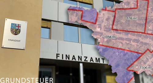
BORIS Saarland (last updated 2024) |
Bodenrichtwerte für Grundsteuerzwecke | |
|
| |
Viewer |
Anwendung | |
| Go to land values application | Zur Anwendung der Bodenrichtwerte für Grundsteuerzwecke |
Description
Land values are available online throughout Saarland with almost full coverage. BORIS Saarland is a land value information system that offers a basic service for free online research. You can run your searches either by entering an address (local government area, street) or by looking for a specific cadastral element (cadastral division, block or cadastral parcel). You can use BORIS Saarland to obtain information about land value zoning.
When you click the ![]() data query button and then click on the ‘map’, an information dialog pops up: this dialog shows you the local government authority, the district, the land value zone number, the land value in €/m², the effective date, the usage type, characteristics affecting the value and details of the competent valuation board for plot values.
The conversion coefficients for the characteristics affecting plot value can be requested for a fee from the respective valuation boards. As always, a written land value assessment can also be obtained by writing to the valuation board.
data query button and then click on the ‘map’, an information dialog pops up: this dialog shows you the local government authority, the district, the land value zone number, the land value in €/m², the effective date, the usage type, characteristics affecting the value and details of the competent valuation board for plot values.
The conversion coefficients for the characteristics affecting plot value can be requested for a fee from the respective valuation boards. As always, a written land value assessment can also be obtained by writing to the valuation board.
Please ensure you have read the terms and conditions of use.
Land values are presented on Geoportal Saarland. Geoportal Saarland forms an integral part of the Saarland spatial data infrastructure and offers a number of applications typical for such an information system.
BORIS Saarland is part of the ‘Networked Land Values Information System’ initiative (VBORIS) from the Working Committee of the Surveying Authorities of the Laender of the Federal Republic of Germany (AdV). The AdV has itself set up the Valuation Board Portal, which offers information at nationwide level about land values and valuation boards.
Explanatory notes on zonal land values
Terminology
A land value (section 196(1) of the German Building Code, BauGB) represents the average situational value of land for a majority of plots within a demarcated area (land value zone) whose plot characteristics are generally similar to one another, especially in terms of the type and degree of usability, and to whom the same general value relationships essentially apply. In each case, a land value references a square surface metre of a plot having the plot characteristics as shown (land value plot).
The land value does not account for any value stemming from greenery, buildings, structures or other facilities. For developed plots, land values are calculated as the value that would result if the ground had not been built on (BauGB section 196(1), sent. 2). Land values are given without reference to potential contamination. Land values do take into account the effects of monument protection on the zone (e.g. ensembles in historical urban centres) but do not consider the impact of monument protection on a single plot.
Any potential deviations of an individual plot from the reference land value plot on account of its plot characteristics (e.g. in terms of its general accessibility or status in terms of fees and duties, or the nature and extent of structural development) should be taken into account when determining the actual market value of the affected plot. Eligible applicants can request a market valuation pursuant to BauGB section 193.
Neither the demarcation of land value zones nor the calculation of the land value itself can be used to justify any claims against urban development planning offices, building authorities or agricultural authorities, for example.
Presentation
The land value is shown with its demarcation line (land value zone) up to a zoom level representing the 1:2,500 scale. A zone number is assigned to each land value zone.
The application allows land value zones to be overlapped on top of one another. In this case, both zones with their corresponding descriptions are then shown in the information pop-up after clicking the ![]() button.
button.
To obtain a written land value assessment or to request additional information about the land values, please contact your competent valuation board.
Instructions
- Instructions for using the portal application
- Video: ‘Portal application information and instructions’
Downloads
Contacts
Central Office for Valuation Boards for Property Values in Saarland
Valuation Board for Property Values for the State Capital of Saarbrücken
Valuation Board for Property Values for the Saarbrücken Regional Association
Valuation Board for Property Values for the Merzig-Wadern Area
Valuation Board for Property Values for the Neunkirchen Area
Valuation Board for Property Values for the Saarlouis Area
Valuation Board for Property Values for the St Wendel Area
Valuation Board for Property Values for the Saarpfalz Area