Das-Geoportal/en: Unterschied zwischen den Versionen
Tschug (Diskussion | Beiträge) |
Tschug (Diskussion | Beiträge) K |
||
| (9 dazwischenliegende Versionen desselben Benutzers werden nicht angezeigt) | |||
| Zeile 1: | Zeile 1: | ||
__NOTOC__ |
__NOTOC__ |
||
| − | == |
+ | == GeoPortal SL == |
| − | + | Within Saarland’s [https://en.wikipedia.org/wiki/Spatial_data_infrastructure spatial data infrastructure] (''SDI''), GeoPortal SL is assigned the task of providing spatial data at a state and municipal level. GeoPortal SL uses electronic networks to provide access to this spatial data. |
|
| + | GeoPortal SL went online in 2010; the portal was subsequently relaunched on 29 June 2020. |
||
| − | <div class="mw-translate-fuzzy"> |
||
| − | Das GeoPortal SL ging 2010 erstmalig in Betrieb, am 29.06.2020 erfolgte ein Relaunch des Portals. |
||
| − | </div> |
||
| + | Geoportal Saarland acts as the main intermediary platform serving users and providers of spatial data in Saarland. As this core component, the portal gives citizens, policymakers, businesses and public administrators a straightforward means to research and visualise geo basic and geo specialist types of spatial data as provided by state and local governments. The portal also offers general information on the topics of spatial data and spatial data infrastructure. |
||
| − | Das Geoportal Saarland ist die zentrale Vermittlerstelle zwischen Nutzern und Anbietern von Geodaten im Saarland. Als Kernelement ermöglicht das Portal den Bürgerinnen und Bürgern, der Politik, der Wirtschaft und der Verwaltung die einfache Recherche und Visualisierung von Geobasis- und Geofachdaten der Landesverwaltung und der Kommunen. Zudem werden allgemeine Informationen rund um das Thema Geodaten und Geodateninfrastruktur bereitgestellt. |
||
| + | <p>As the EU INSPIRE Directive requires Member States to guarantee access to their spatial data (services), Saarland’s Spatial Data Infrastructure Act (SGDIG 2009, section 8) tasks the State Office for Surveying, Geoinformation and Land Development (LVGL) with establishing a central access point for users. Accordingly, the Geoportal is responsible for enabling targeted access to shared mapping and data services, and ensuring that these can be usefully combined with one another. In this context, metadata and catalogue services form an indispensable part of spatial data, service and application discovery within a spatial data infrastructure: without their appropriate provision, information about the available services and data can neither be researched nor effectively accessed.</p> |
||
| − | <p>Da die INSPIRE-Richtlinie die Mitgliedstaaten verpflichtet, den Zugang zu ihren Geodaten und -diensten zu gewährleisten, ist nach Saarländischen Geodateninfrastrukturgesetz (§ 8 SGDIG 2009) vom Landesamt für Vermessung, Geoinformation und Landentwicklung (LVGL) ein zentraler Zugangspunkt für die Nutzer einzurichten. Dabei übernimmt das Geoportal die Aufgabe, den gezielten Zugriff auf verteilte Karten- und Datendienste zu ermöglichen und diese in sinnvoller Kombination nutzbar zu machen. In diesem Zusammenhang sind Metadaten und Katalogdienste zum Auffinden von Geodaten, Diensten und Anwendungen unverzichtbare Bestandteile der Geodateninfrastruktur, erst durch sie werden Informationen über die vorhandenen Dienste und Daten recherchierbar und effektiv zugänglich.</p> |
||
| + | <p>The spatial data on the platform is usable 24 hours a day and without waiting times, both for specialist public administration and business users as well as ordinary citizens, helping them to stay well-informed about the many decisions needing to be clarified in both a personal and professional capacity. The number of records held and the range of applications on offer have both increased since the portal was created. Currently, the Portal has over 5,000 map layers and over 40 thematic applications on offer (including standard land values, protected area registries, noise pollution mapping, flood hazard maps, wind power atlases, forestry/agriculture, soil and geology, spatial planning, transport, etc.). By uploading their legally binding zoning plans, many municipalities in Saarland have also significantly expanded the online services they provide to their citizens.</p> |
||
| − | <p>Für die Fachanwender in der öffentlichen Verwaltung und in der Wirtschaft aber auch für Bürgerinnen und Bürger werden ganztags und ohne Wartezeiten die eingestellten Geodaten des Landes nutzbar sein, so dass vielfältige Entscheidungen im privaten und professionellen Umfeld besser vorbereitet werden können. Zahlreiche Geoinformationen etwa zum Straßennetz, Schutzgebiete, Überschwemmungsgebiete, Bodenkarten, Orthophotos und Topographische Karten können abgerufen und miteinander kombiniert werden. Die Geodatenanbieter sind derzeit behördliche Institutionen aus dem Umweltressort wie das Ministerium für Umwelt, Energie und Verkehr sowie seine nachgeordneten Behörden, die ihre Webservices im Portal registrieren und damit öffentlich machen. Zudem wurden aber auch bereits kommunale Geodaten wie beispielsweise Bebauungspläne eingebunden.</p> |
||
| + | <p>Created by a developer community consisting of the GDI Coordinating Units in Hesse, Rhineland-Palatinate and Saarland, the system is based on free and open source software, and undergoes a continuous process of expansion, modernisation and optimisation.</p> |
||
| − | <p>Das GeoPortal Saarland wurde aus dem GeoPortal.rlp entwickelt. Alle relevanten Bestandteile des GeoPortals basieren auf Open-Source-Software (OSS).</p> |
||
<p>[[File:Geoportal_abb.jpg|alt=Geoportal|600px|link=]]</p> |
<p>[[File:Geoportal_abb.jpg|alt=Geoportal|600px|link=]]</p> |
||
Aktuelle Version vom 22. November 2022, 13:55 Uhr
GeoPortal SL
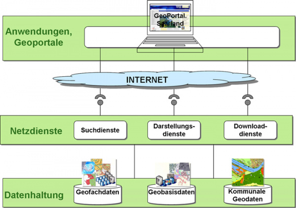
Within Saarland’s spatial data infrastructure (SDI), GeoPortal SL is assigned the task of providing spatial data at a state and municipal level. GeoPortal SL uses electronic networks to provide access to this spatial data.
GeoPortal SL went online in 2010; the portal was subsequently relaunched on 29 June 2020.
Geoportal Saarland acts as the main intermediary platform serving users and providers of spatial data in Saarland. As this core component, the portal gives citizens, policymakers, businesses and public administrators a straightforward means to research and visualise geo basic and geo specialist types of spatial data as provided by state and local governments. The portal also offers general information on the topics of spatial data and spatial data infrastructure.
As the EU INSPIRE Directive requires Member States to guarantee access to their spatial data (services), Saarland’s Spatial Data Infrastructure Act (SGDIG 2009, section 8) tasks the State Office for Surveying, Geoinformation and Land Development (LVGL) with establishing a central access point for users. Accordingly, the Geoportal is responsible for enabling targeted access to shared mapping and data services, and ensuring that these can be usefully combined with one another. In this context, metadata and catalogue services form an indispensable part of spatial data, service and application discovery within a spatial data infrastructure: without their appropriate provision, information about the available services and data can neither be researched nor effectively accessed.
The spatial data on the platform is usable 24 hours a day and without waiting times, both for specialist public administration and business users as well as ordinary citizens, helping them to stay well-informed about the many decisions needing to be clarified in both a personal and professional capacity. The number of records held and the range of applications on offer have both increased since the portal was created. Currently, the Portal has over 5,000 map layers and over 40 thematic applications on offer (including standard land values, protected area registries, noise pollution mapping, flood hazard maps, wind power atlases, forestry/agriculture, soil and geology, spatial planning, transport, etc.). By uploading their legally binding zoning plans, many municipalities in Saarland have also significantly expanded the online services they provide to their citizens.
Created by a developer community consisting of the GDI Coordinating Units in Hesse, Rhineland-Palatinate and Saarland, the system is based on free and open source software, and undergoes a continuous process of expansion, modernisation and optimisation.