INSPIRE und GDI/en: Unterschied zwischen den Versionen
Tschug (Diskussion | Beiträge) |
Tschug (Diskussion | Beiträge) K |
||
| (2 dazwischenliegende Versionen desselben Benutzers werden nicht angezeigt) | |||
| Zeile 13: | Zeile 13: | ||
=== Organisation === |
=== Organisation === |
||
| − | <p>At Community level, the Commission is responsible for INSPIRE coordination and is supported in this work by the corresponding organisations, and the European Environment Agency (EEA) in particular. In Member States, national contact points have been designated who are responsible for maintaining dialogue with the Commission in the context of the Directive. In Germany, these are the GDI-DE Steering Committee and the GDI-DE Coordination Unit. The GDI-DE Coordination Unit handles operational tasks related to implementation and is supported by state-level contact offices. In Saarland, this office is the Spatial Data Centre within the State Office for Surveying, |
+ | <p>At Community level, the Commission is responsible for INSPIRE coordination and is supported in this work by the corresponding organisations, and the European Environment Agency (EEA) in particular. In Member States, national contact points have been designated who are responsible for maintaining dialogue with the Commission in the context of the Directive. In Germany, these are the GDI-DE Steering Committee and the GDI-DE Coordination Unit. The GDI-DE Coordination Unit handles operational tasks related to implementation and is supported by state-level contact offices. In Saarland, this office is the Spatial Data Centre within the State Office for Surveying, Geoinformation and Land Development (LVGL).</p> |
=== SDI – spatial data infrastructure === |
=== SDI – spatial data infrastructure === |
||
| Zeile 27: | Zeile 27: | ||
<p>The Directive requires Member States to establish a timetable for the provisioning of '''metadata''', the provisioning of INSPIRE-compliant '''search and presentation services''' for all identified spatial datasets and services, and last but not least, the provisioning of spatial data in use by means of a '''standardised format'''. From 2021, INSPIRE-relevant spatial data from all over Europe should be able to be used in standardised data formats.</p> |
<p>The Directive requires Member States to establish a timetable for the provisioning of '''metadata''', the provisioning of INSPIRE-compliant '''search and presentation services''' for all identified spatial datasets and services, and last but not least, the provisioning of spatial data in use by means of a '''standardised format'''. From 2021, INSPIRE-relevant spatial data from all over Europe should be able to be used in standardised data formats.</p> |
||
| + | <p>Member States are required to submit reports about the setup and operation of their SDIs. To this end, key figures about infrastructure elements and content – such as services, data and metadata – are collected, analysed and published on an annual basis. Annual reports have been sent for publication to the Commission since 15 May 2010.<br /> |
||
| − | <p>Die Mitgliedstaaten sind verpflichtet über den Aufbau und den Betrieb ihrer GDI zu berichten. Hierfür werden jedes Jahr Kennzahlen zu den Infrastrukturelementen und –inhalten wie Dienste, Daten und Metadaten erhoben, ausgewertet und veröffentlicht. Ab dem 15.5.10 wird jährlich ein Bericht an die Kommission gesendet und veröffentlicht.<br /> |
||
<br /> |
<br /> |
||
| + | The central European access point for INSPIRE-relevant data in the form of services is the EU Commission’s INSPIRE Geoportal. In Germany, the metadata-enriched spatial data and spatial data services are registered in state-level portals and harvested during a regular cycle into Geoportal DE – the federal-level spatial data catalogue. If the spatial dataset has INSPIRE relevance and the metadata dataset includes the keyword ‘inspire-identified’, the dataset is uploaded from the federal portal to the EU INSPIRE Geoportal.<br /> |
||
| − | Zentraler europäischer Zugangsknoten zu den INSPIRE-relevanten Daten in Form von Diensten ist das INSPIRE Geoportal der EU Kommission. In Deutschland werden die mit Metadaten beschriebenen Geodaten und Geodatendienste in den Länderportalen registriert und in einem regelmäßigen Zyklus in den Geodatenkatalog des Bundes, das Geoportal DE, geharvestet. Sofern der Geodatensatz INSPIRE-betroffen ist und der Metadatensatz das Schlüsselwort „inspireidentifiziert“ enthält, wird er aus dem Bundesportal ins INSPIRE Geoportal der EU übernommen.<br /> |
||
<br /> |
<br /> |
||
| − | [[File:Monitoring.png|601px|alt= |
+ | [[File:Monitoring.png|601px|alt=Graphic monitoring|link=]]</p> |
| + | == Further information == |
||
| − | == Weiterführende Informationen == |
||
<ul> |
<ul> |
||
Aktuelle Version vom 22. November 2022, 13:57 Uhr
INSPIRE and spatial data infrastructure (SDI)
INSPIRE (Infrastructure for Spatial Information in Europe) is shorthand for ‘Directive 2007/2/EC of the European Parliament and of the Council establishing an Infrastructure for Spatial Information in the European Community’. Following its entry into force on 15 May 2007, EU Member States were then given a period of two years to transpose the Directive into national law. The Directive aims to establish a general framework for the creation of spatial data infrastructure in the EU to further the purposes of Community policy on the environment. With the INSPIRE Directive, an instrument has been created to simplify the access to and usage of spatial data by private citizens, public administrations and businesses.
In Germany, the Directive was transposed into federal law with the entry into force of the Spatial Data Access Act (Geodatenzugangsgesetz, GeoZG) on 10 February 2009. In Saarland, the Directive was transposed into state law by the Saarland Spatial Data Infrastructure Act (Geodateninfrastrukturgesetz, SGDIG) in July 2009.
Involved parties
The Directive is aimed at all public authorities that hold spatial data. In terms of applications, INSPIRE is restricted to 34 data themes, which are listed in three annexes. INSPIRE also requires spatial data to be described by metadata. In Germany, implementation involves authorities at federal, state and local level, since various competencies exist for the spatial data. Many subject-specific and technical details are not covered by the Directive: in these cases, details are governed by implementing rules and transposition guidelines. These are drafted step by step for the INSPIRE themes and then transposed into national law by EU Member States.
Organisation
At Community level, the Commission is responsible for INSPIRE coordination and is supported in this work by the corresponding organisations, and the European Environment Agency (EEA) in particular. In Member States, national contact points have been designated who are responsible for maintaining dialogue with the Commission in the context of the Directive. In Germany, these are the GDI-DE Steering Committee and the GDI-DE Coordination Unit. The GDI-DE Coordination Unit handles operational tasks related to implementation and is supported by state-level contact offices. In Saarland, this office is the Spatial Data Centre within the State Office for Surveying, Geoinformation and Land Development (LVGL).
SDI – spatial data infrastructure
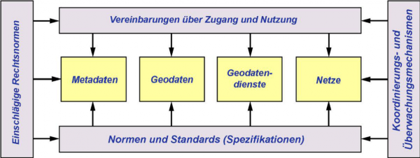
A spatial data infrastructure (SDI) consists of spatial data, spatial metadata and spatial data services, as well as network services and technologies based on national and international standards. Alongside its technical components, an SDI also requires the creation of a general organisational framework, such as agreements concerning usage and access as well as coordination and monitoring mechanisms.

The establishment of a spatial data infrastructure in Germany (GDI-DE) and in Saarland (GDI-SL) aims to improve the provisioning and usage of the distributed spatial datasets held by various parts (and at various levels) of the administration, and to network spatial data across German states and administrative departments by means of standardised internet services for searches, visualisation and data access.
Monitoring
The Directive requires Member States to establish a timetable for the provisioning of metadata, the provisioning of INSPIRE-compliant search and presentation services for all identified spatial datasets and services, and last but not least, the provisioning of spatial data in use by means of a standardised format. From 2021, INSPIRE-relevant spatial data from all over Europe should be able to be used in standardised data formats.
Member States are required to submit reports about the setup and operation of their SDIs. To this end, key figures about infrastructure elements and content – such as services, data and metadata – are collected, analysed and published on an annual basis. Annual reports have been sent for publication to the Commission since 15 May 2010.
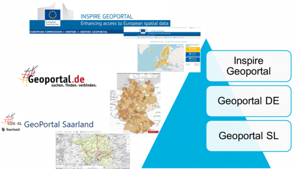
The central European access point for INSPIRE-relevant data in the form of services is the EU Commission’s INSPIRE Geoportal. In Germany, the metadata-enriched spatial data and spatial data services are registered in state-level portals and harvested during a regular cycle into Geoportal DE – the federal-level spatial data catalogue. If the spatial dataset has INSPIRE relevance and the metadata dataset includes the keyword ‘inspire-identified’, the dataset is uploaded from the federal portal to the EU INSPIRE Geoportal.
