Bodenrichtwerte/en: Unterschied zwischen den Versionen
Tschug (Diskussion | Beiträge) |
Tschug (Diskussion | Beiträge) K |
||
| (3 dazwischenliegende Versionen von 2 Benutzern werden nicht angezeigt) | |||
| Zeile 1: | Zeile 1: | ||
__NOTOC__ |
__NOTOC__ |
||
| + | |||
=== <p style="color: red;">Hinweis zur Grundsteuerreform</p> === |
=== <p style="color: red;">Hinweis zur Grundsteuerreform</p> === |
||
| − | <p style="color: red;">Wenn Sie den Bodenrichtwert Ihres Grundstücks |
+ | <p style="color: red;">Wenn Sie den Bodenrichtwert Ihres Grundstücks zur Erstellung der <strong>Feststellungserklärung für den Grundsteuerwert</strong> (Hauptfeststellung im Rahmen der Grundsteuerreform) abfragen wollen, wählen Sie bitte die Anwendung <strong>„Bodenrichtwerte für Grundsteuerzwecke“</strong> aus.<br /> |
<br /> |
<br /> |
||
<strong>Bitte geben Sie ausschließlich die Werte aus der Anwendung „Bodenrichtwerte für Grundsteuerzwecke“ in Ihrer Feststellungserklärung an.</strong></p> |
<strong>Bitte geben Sie ausschließlich die Werte aus der Anwendung „Bodenrichtwerte für Grundsteuerzwecke“ in Ihrer Feststellungserklärung an.</strong></p> |
||
| − | <div class="mw-translate-fuzzy"> |
||
{| style="width: 80%; vertical-align:top; text-align: left;" |
{| style="width: 80%; vertical-align:top; text-align: left;" |
||
| − | |width="40%"|<h2> BORIS Saarland (last updated |
+ | |width="40%"|<h2> BORIS Saarland (last updated 2024) </h2> |
|style="width: 10%"| |
|style="width: 10%"| |
||
| − | |width="40%"|<h2> Bodenrichtwerte für Grundsteuerzwecke |
+ | |width="40%"|<h2> Bodenrichtwerte für Grundsteuerzwecke </h2> |
|- |
|- |
||
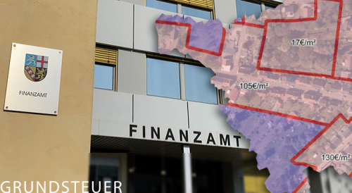
|width="40%"|[[File:Fachanwendung-Bodenrichtwerte-Schaubild.jpg|alt=BORIS|500px|link=//{{SERVERNAME}}/mapbender/frames/index.php?lang=de&gui_id=Geoportal-SL-2020&WMC=3019]] |
|width="40%"|[[File:Fachanwendung-Bodenrichtwerte-Schaubild.jpg|alt=BORIS|500px|link=//{{SERVERNAME}}/mapbender/frames/index.php?lang=de&gui_id=Geoportal-SL-2020&WMC=3019]] |
||
| Zeile 26: | Zeile 26: | ||
</ul> |
</ul> |
||
|} |
|} |
||
| − | </div> |
||
== Description == |
== Description == |
||
| Zeile 71: | Zeile 70: | ||
== Contacts == |
== Contacts == |
||
| − | <p>[https://www.saarland.de/lvgl/DE/themen-aufgaben/themen/zgga |
+ | <p>[https://www.saarland.de/lvgl/DE/themen-aufgaben/themen/zgga Central Office for Valuation Boards for Property Values in Saarland]<br /> |
| − | [https://www.saarland.de/lvgl/DE/themen-aufgaben/themen/zgga/gutachterausschuesse/gutachterstadtsaarbruecken |
+ | [https://www.saarland.de/lvgl/DE/themen-aufgaben/themen/zgga/gutachterausschuesse/gutachterstadtsaarbruecken Valuation Board for Property Values for the State Capital of Saarbrücken]<br /> |
| − | [https://www.saarland.de/lvgl/DE/themen-aufgaben/themen/zgga/gutachterausschuesse/gutachterausschussreginalsb |
+ | [https://www.saarland.de/lvgl/DE/themen-aufgaben/themen/zgga/gutachterausschuesse/gutachterausschussreginalsb Valuation Board for Property Values for the Saarbrücken Regional Association]<br /> |
| − | [https://www.saarland.de/lvgl/DE/themen-aufgaben/themen/zgga/gutachterausschuesse/gutachterausschussmerzigwadern |
+ | [https://www.saarland.de/lvgl/DE/themen-aufgaben/themen/zgga/gutachterausschuesse/gutachterausschussmerzigwadern Valuation Board for Property Values for the Merzig-Wadern Area]<br /> |
| − | [https://www.saarland.de/lvgl/DE/themen-aufgaben/themen/zgga/gutachterausschuesse/gutachterausschussneunkirchen |
+ | [https://www.saarland.de/lvgl/DE/themen-aufgaben/themen/zgga/gutachterausschuesse/gutachterausschussneunkirchen Valuation Board for Property Values for the Neunkirchen Area]<br /> |
| − | [https://www.saarland.de/lvgl/DE/themen-aufgaben/themen/zgga/gutachterausschuesse/gutachterausschusssaarlouis |
+ | [https://www.saarland.de/lvgl/DE/themen-aufgaben/themen/zgga/gutachterausschuesse/gutachterausschusssaarlouis Valuation Board for Property Values for the Saarlouis Area]<br /> |
| − | [https://www.saarland.de/lvgl/DE/themen-aufgaben/themen/zgga/gutachterausschuesse/gutachterausschusswnd |
+ | [https://www.saarland.de/lvgl/DE/themen-aufgaben/themen/zgga/gutachterausschuesse/gutachterausschusswnd Valuation Board for Property Values for the St Wendel Area]<br /> |
| − | [https://www.saarland.de/lvgl/DE/themen-aufgaben/themen/zgga/gutachterausschuesse/gutachterausschusssaarpfalz |
+ | [https://www.saarland.de/lvgl/DE/themen-aufgaben/themen/zgga/gutachterausschuesse/gutachterausschusssaarpfalz Valuation Board for Property Values for the Saarpfalz Area]<br /></p> |
Aktuelle Version vom 12. Mai 2025, 10:01 Uhr
Hinweis zur Grundsteuerreform
Wenn Sie den Bodenrichtwert Ihres Grundstücks zur Erstellung der Feststellungserklärung für den Grundsteuerwert (Hauptfeststellung im Rahmen der Grundsteuerreform) abfragen wollen, wählen Sie bitte die Anwendung „Bodenrichtwerte für Grundsteuerzwecke“ aus.
Bitte geben Sie ausschließlich die Werte aus der Anwendung „Bodenrichtwerte für Grundsteuerzwecke“ in Ihrer Feststellungserklärung an.
BORIS Saarland (last updated 2024) |
Bodenrichtwerte für Grundsteuerzwecke | |
|
| |
Viewer |
Anwendung | |
| Go to land values application | Zur Anwendung der Bodenrichtwerte für Grundsteuerzwecke |
Description
Land values are available online throughout Saarland with almost full coverage. BORIS Saarland is a land value information system that offers a basic service for free online research. You can run your searches either by entering an address (local government area, street) or by looking for a specific cadastral element (cadastral division, block or cadastral parcel). You can use BORIS Saarland to obtain information about land value zoning.
When you click the ![]() data query button and then click on the ‘map’, an information dialog pops up: this dialog shows you the local government authority, the district, the land value zone number, the land value in €/m², the effective date, the usage type, characteristics affecting the value and details of the competent valuation board for plot values.
The conversion coefficients for the characteristics affecting plot value can be requested for a fee from the respective valuation boards. As always, a written land value assessment can also be obtained by writing to the valuation board.
data query button and then click on the ‘map’, an information dialog pops up: this dialog shows you the local government authority, the district, the land value zone number, the land value in €/m², the effective date, the usage type, characteristics affecting the value and details of the competent valuation board for plot values.
The conversion coefficients for the characteristics affecting plot value can be requested for a fee from the respective valuation boards. As always, a written land value assessment can also be obtained by writing to the valuation board.
Please ensure you have read the terms and conditions of use.
Land values are presented on Geoportal Saarland. Geoportal Saarland forms an integral part of the Saarland spatial data infrastructure and offers a number of applications typical for such an information system.
BORIS Saarland is part of the ‘Networked Land Values Information System’ initiative (VBORIS) from the Working Committee of the Surveying Authorities of the Laender of the Federal Republic of Germany (AdV). The AdV has itself set up the Valuation Board Portal, which offers information at nationwide level about land values and valuation boards.
Explanatory notes on zonal land values
Terminology
A land value (section 196(1) of the German Building Code, BauGB) represents the average situational value of land for a majority of plots within a demarcated area (land value zone) whose plot characteristics are generally similar to one another, especially in terms of the type and degree of usability, and to whom the same general value relationships essentially apply. In each case, a land value references a square surface metre of a plot having the plot characteristics as shown (land value plot).
The land value does not account for any value stemming from greenery, buildings, structures or other facilities. For developed plots, land values are calculated as the value that would result if the ground had not been built on (BauGB section 196(1), sent. 2). Land values are given without reference to potential contamination. Land values do take into account the effects of monument protection on the zone (e.g. ensembles in historical urban centres) but do not consider the impact of monument protection on a single plot.
Any potential deviations of an individual plot from the reference land value plot on account of its plot characteristics (e.g. in terms of its general accessibility or status in terms of fees and duties, or the nature and extent of structural development) should be taken into account when determining the actual market value of the affected plot. Eligible applicants can request a market valuation pursuant to BauGB section 193.
Neither the demarcation of land value zones nor the calculation of the land value itself can be used to justify any claims against urban development planning offices, building authorities or agricultural authorities, for example.
Presentation
The land value is shown with its demarcation line (land value zone) up to a zoom level representing the 1:2,500 scale. A zone number is assigned to each land value zone.
The application allows land value zones to be overlapped on top of one another. In this case, both zones with their corresponding descriptions are then shown in the information pop-up after clicking the ![]() button.
button.
To obtain a written land value assessment or to request additional information about the land values, please contact your competent valuation board.
Instructions
- Instructions for using the portal application
- Video: ‘Portal application information and instructions’
Downloads
Contacts
Central Office for Valuation Boards for Property Values in Saarland
Valuation Board for Property Values for the State Capital of Saarbrücken
Valuation Board for Property Values for the Saarbrücken Regional Association
Valuation Board for Property Values for the Merzig-Wadern Area
Valuation Board for Property Values for the Neunkirchen Area
Valuation Board for Property Values for the Saarlouis Area
Valuation Board for Property Values for the St Wendel Area
Valuation Board for Property Values for the Saarpfalz Area