Bebauungsplaene/en: Unterschied zwischen den Versionen
Tschug (Diskussion | Beiträge) K |
Plang (Diskussion | Beiträge) |
||
| (4 dazwischenliegende Versionen von 2 Benutzern werden nicht angezeigt) | |||
| Zeile 1: | Zeile 1: | ||
| + | __NOTOC__ |
||
| + | |||
| + | |||
== Zoning/land development plans from local authorities in Saarland == |
== Zoning/land development plans from local authorities in Saarland == |
||
| Zeile 35: | Zeile 38: | ||
| [[File:LogoEppelborn.jpg|x70px|alt=Logo Eppelborn LGA|Eppelborn LGA|link=//{{SERVERNAME}}/mapbender/frames/index.php?lang=de&gui_id=Geoportal-SL-2020&WMC=2941]][//{{SERVERNAME}}/mapbender/frames/index.php?lang=de&gui_id=Geoportal-SL-2020&WMC=2941 <br />Eppelborn LGA] |
| [[File:LogoEppelborn.jpg|x70px|alt=Logo Eppelborn LGA|Eppelborn LGA|link=//{{SERVERNAME}}/mapbender/frames/index.php?lang=de&gui_id=Geoportal-SL-2020&WMC=2941]][//{{SERVERNAME}}/mapbender/frames/index.php?lang=de&gui_id=Geoportal-SL-2020&WMC=2941 <br />Eppelborn LGA] |
||
| [[File:logo_friedrichsthal.jpg|x70px|alt=Logo City Friedrichsthal|City of Friedrichsthal|link=//{{SERVERNAME}}/mapbender/frames/index.php?lang=de&gui_id=Geoportal-SL-2020&WMC=3496]][//{{SERVERNAME}}/mapbender/frames/index.php?lang=de&gui_id=Geoportal-SL-2020&WMC=3496 <br />City of Friedrichsthal] |
| [[File:logo_friedrichsthal.jpg|x70px|alt=Logo City Friedrichsthal|City of Friedrichsthal|link=//{{SERVERNAME}}/mapbender/frames/index.php?lang=de&gui_id=Geoportal-SL-2020&WMC=3496]][//{{SERVERNAME}}/mapbender/frames/index.php?lang=de&gui_id=Geoportal-SL-2020&WMC=3496 <br />City of Friedrichsthal] |
||
| − | | [[File: |
+ | | [[File:Logo_gersheim.png|x70px|alt=Logo Gersheim LGA|Gersheim LGA|link=//{{SERVERNAME}}/mapbender/frames/index.php?lang=de&gui_id=Geoportal-SL-2020&WMC=3326]][//{{SERVERNAME}}/mapbender/frames/index.php?lang=de&gui_id=Geoportal-SL-2020&WMC=3326 <br />Gersheim LGA] |
| |
| |
||
|- |
|- |
||
| Zeile 55: | Zeile 58: | ||
| [[File:logo_Illingen.jpg|x70px|alt=Logo Illingen LGA|Illingen LGA|link=//{{SERVERNAME}}/mapbender/frames/index.php?lang=de&gui_id=Geoportal-SL-2020&WMC=3280]][//{{SERVERNAME}}/mapbender/frames/index.php?lang=de&gui_id=Geoportal-SL-2020&WMC=3280 <br />Illingen LGA] |
| [[File:logo_Illingen.jpg|x70px|alt=Logo Illingen LGA|Illingen LGA|link=//{{SERVERNAME}}/mapbender/frames/index.php?lang=de&gui_id=Geoportal-SL-2020&WMC=3280]][//{{SERVERNAME}}/mapbender/frames/index.php?lang=de&gui_id=Geoportal-SL-2020&WMC=3280 <br />Illingen LGA] |
||
| [[File:logo_Kleinblittersdorf.jpg|x70px|alt=Logo Kleinblittersdorf LGA|Kleinblittersdorf LGA|link=//{{SERVERNAME}}/mapbender/frames/index.php?lang=de&gui_id=Geoportal-SL-2020&WMC=2942]][//{{SERVERNAME}}/mapbender/frames/index.php?lang=de&gui_id=Geoportal-SL-2020&WMC=2942 <br />Kleinblittersdorf LGA] |
| [[File:logo_Kleinblittersdorf.jpg|x70px|alt=Logo Kleinblittersdorf LGA|Kleinblittersdorf LGA|link=//{{SERVERNAME}}/mapbender/frames/index.php?lang=de&gui_id=Geoportal-SL-2020&WMC=2942]][//{{SERVERNAME}}/mapbender/frames/index.php?lang=de&gui_id=Geoportal-SL-2020&WMC=2942 <br />Kleinblittersdorf LGA] |
||
| − | | [[File: |
+ | | [[File:logo_Losheim.jpg|x90px|alt=Logo Losheim LGA|Losheim LGA|link=//{{SERVERNAME}}/mapbender/frames/index.php?lang=de&gui_id=Geoportal-SL-2020&WMC=7713]][//{{SERVERNAME}}/mapbender/frames/index.php?lang=de&gui_id=Geoportal-SL-2020&WMC=7713 <br />Losheim LGA] |
| |
| |
||
|- |
|- |
||
| Zeile 63: | Zeile 66: | ||
| |
| |
||
|- |
|- |
||
| ⚫ | |||
| [[File:logo_Marpingen.jpg|x70px|alt=Logo Marpingen LGA|Marpingen LGA|link=//{{SERVERNAME}}/mapbender/frames/index.php?lang=de&gui_id=Geoportal-SL-2020&WMC=3118]][//{{SERVERNAME}}/mapbender/frames/index.php?lang=de&gui_id=Geoportal-SL-2020&WMC=3118 <br />Marpingen LGA] |
| [[File:logo_Marpingen.jpg|x70px|alt=Logo Marpingen LGA|Marpingen LGA|link=//{{SERVERNAME}}/mapbender/frames/index.php?lang=de&gui_id=Geoportal-SL-2020&WMC=3118]][//{{SERVERNAME}}/mapbender/frames/index.php?lang=de&gui_id=Geoportal-SL-2020&WMC=3118 <br />Marpingen LGA] |
||
| [[File:logo_merchweiler.jpg|x70px|alt=Logo Merchweiler LGA|Merchweiler LGA|link=//{{SERVERNAME}}/mapbender/frames/index.php?lang=de&gui_id=Geoportal-SL-2020&WMC=3883]][//{{SERVERNAME}}/mapbender/frames/index.php?lang=de&gui_id=Geoportal-SL-2020&WMC=3883 <br />Merchweiler LGA] |
| [[File:logo_merchweiler.jpg|x70px|alt=Logo Merchweiler LGA|Merchweiler LGA|link=//{{SERVERNAME}}/mapbender/frames/index.php?lang=de&gui_id=Geoportal-SL-2020&WMC=3883]][//{{SERVERNAME}}/mapbender/frames/index.php?lang=de&gui_id=Geoportal-SL-2020&WMC=3883 <br />Merchweiler LGA] |
||
| ⚫ | |||
| |
| |
||
|- |
|- |
||
| Zeile 73: | Zeile 76: | ||
| |
| |
||
|- |
|- |
||
| ⚫ | |||
| [[File:logo_mettlach.jpg|x70px|alt=Logo Mettlach LGA|Mettlach LGA|link=//{{SERVERNAME}}/mapbender/frames/index.php?lang=de&gui_id=Geoportal-SL-2020&WMC=4530]][//{{SERVERNAME}}/mapbender/frames/index.php?lang=de&gui_id=Geoportal-SL-2020&WMC=4530 <br />Mettlach LGA] |
| [[File:logo_mettlach.jpg|x70px|alt=Logo Mettlach LGA|Mettlach LGA|link=//{{SERVERNAME}}/mapbender/frames/index.php?lang=de&gui_id=Geoportal-SL-2020&WMC=4530]][//{{SERVERNAME}}/mapbender/frames/index.php?lang=de&gui_id=Geoportal-SL-2020&WMC=4530 <br />Mettlach LGA] |
||
| [[File:logo_Nalbach.jpg|x70px|alt=Logo Nalbach LGA|Nalbach LGA|link=//{{SERVERNAME}}/mapbender/frames/index.php?lang=de&gui_id=Geoportal-SL-2020&WMC=4955]][//{{SERVERNAME}}/mapbender/frames/index.php?lang=de&gui_id=Geoportal-SL-2020&WMC=4955 <br />Nalbach LGA] |
| [[File:logo_Nalbach.jpg|x70px|alt=Logo Nalbach LGA|Nalbach LGA|link=//{{SERVERNAME}}/mapbender/frames/index.php?lang=de&gui_id=Geoportal-SL-2020&WMC=4955]][//{{SERVERNAME}}/mapbender/frames/index.php?lang=de&gui_id=Geoportal-SL-2020&WMC=4955 <br />Nalbach LGA] |
||
| ⚫ | |||
| |
| |
||
| |
| |
||
| Zeile 84: | Zeile 87: | ||
| |
| |
||
|- |
|- |
||
| ⚫ | |||
| [[File:logo_Nonnweiler.jpg|x70px|alt=Logo Nonnweiler LGA|Nonnweiler LGA|link=//{{SERVERNAME}}/mapbender/frames/index.php?lang=de&gui_id=Geoportal-SL-2020&WMC=3310]][//{{SERVERNAME}}/mapbender/frames/index.php?lang=de&gui_id=Geoportal-SL-2020&WMC=3310 <br />Nonnweiler LGA] |
| [[File:logo_Nonnweiler.jpg|x70px|alt=Logo Nonnweiler LGA|Nonnweiler LGA|link=//{{SERVERNAME}}/mapbender/frames/index.php?lang=de&gui_id=Geoportal-SL-2020&WMC=3310]][//{{SERVERNAME}}/mapbender/frames/index.php?lang=de&gui_id=Geoportal-SL-2020&WMC=3310 <br />Nonnweiler LGA] |
||
| [[File:logo_puettlingen.jpg|x70px|alt=Coat of arms City Püttlingen|City of Püttlingen|link=//{{SERVERNAME}}/mapbender/frames/index.php?lang=de&gui_id=Geoportal-SL-2020&WMC=3948]][//{{SERVERNAME}}/mapbender/frames/index.php?lang=de&gui_id=Geoportal-SL-2020&WMC=3948 <br />City of Püttlingen] |
| [[File:logo_puettlingen.jpg|x70px|alt=Coat of arms City Püttlingen|City of Püttlingen|link=//{{SERVERNAME}}/mapbender/frames/index.php?lang=de&gui_id=Geoportal-SL-2020&WMC=3948]][//{{SERVERNAME}}/mapbender/frames/index.php?lang=de&gui_id=Geoportal-SL-2020&WMC=3948 <br />City of Püttlingen] |
||
| ⚫ | |||
| |
| |
||
| |
| |
||
| Zeile 95: | Zeile 98: | ||
| |
| |
||
|- |
|- |
||
| ⚫ | |||
| [[File:logo_rehlingen_siersburg.jpg|x70px|alt=Logo Rehlingen-Siersburg LGA|Rehlingen-Siersburg LGA|link=//{{SERVERNAME}}/mapbender/frames/index.php?lang=de&gui_id=Geoportal-SL-2020&WMC=4366]][//{{SERVERNAME}}/mapbender/frames/index.php?lang=de&gui_id=Geoportal-SL-2020&WMC=4366 <br />Rehlingen-Siersburg LGA] |
| [[File:logo_rehlingen_siersburg.jpg|x70px|alt=Logo Rehlingen-Siersburg LGA|Rehlingen-Siersburg LGA|link=//{{SERVERNAME}}/mapbender/frames/index.php?lang=de&gui_id=Geoportal-SL-2020&WMC=4366]][//{{SERVERNAME}}/mapbender/frames/index.php?lang=de&gui_id=Geoportal-SL-2020&WMC=4366 <br />Rehlingen-Siersburg LGA] |
||
| [[File:logo_riegelsberg.jpg|x70px|alt=Logo Riegelsberg LGA|Riegelsberg LGA|link=//{{SERVERNAME}}/mapbender/frames/index.php?lang=de&gui_id=Geoportal-SL-2020&WMC=3572]][//{{SERVERNAME}}/mapbender/frames/index.php?lang=de&gui_id=Geoportal-SL-2020&WMC=3572 <br />Riegelsberg LGA] |
| [[File:logo_riegelsberg.jpg|x70px|alt=Logo Riegelsberg LGA|Riegelsberg LGA|link=//{{SERVERNAME}}/mapbender/frames/index.php?lang=de&gui_id=Geoportal-SL-2020&WMC=3572]][//{{SERVERNAME}}/mapbender/frames/index.php?lang=de&gui_id=Geoportal-SL-2020&WMC=3572 <br />Riegelsberg LGA] |
||
| ⚫ | | [[File:regionalverband_logo.jpg|x70px|alt=Logo Saarbrücken Regional Association|Saarbrücken Regional Association|link=//{{SERVERNAME}}/mapbender/frames/index.php?lang=de&gui_id=Geoportal-SL-2020&WMC=3960]][//{{SERVERNAME}}/mapbender/frames/index.php?lang=de&gui_id=Geoportal-SL-2020&WMC=3960 <br />Saarbrücken Regional Association] |
||
| |
| |
||
| |
| |
||
| Zeile 106: | Zeile 109: | ||
| |
| |
||
|- |
|- |
||
| ⚫ | | [[File:regionalverband_logo.jpg|x70px|alt=Logo Saarbrücken Regional Association|Saarbrücken Regional Association|link=//{{SERVERNAME}}/mapbender/frames/index.php?lang=de&gui_id=Geoportal-SL-2020&WMC=3960]][//{{SERVERNAME}}/mapbender/frames/index.php?lang=de&gui_id=Geoportal-SL-2020&WMC=3960 <br />Saarbrücken Regional Association] |
||
| [[File:logo_saarlouis.png|x70px|alt=Logo City Saarlouis|City of Saarlouis|link=//{{SERVERNAME}}/mapbender/frames/index.php?lang=de&gui_id=Geoportal-SL-2020&WMC=3219]][//{{SERVERNAME}}/mapbender/frames/index.php?lang=de&gui_id=Geoportal-SL-2020&WMC=3219 <br />City of Saarlouis] |
| [[File:logo_saarlouis.png|x70px|alt=Logo City Saarlouis|City of Saarlouis|link=//{{SERVERNAME}}/mapbender/frames/index.php?lang=de&gui_id=Geoportal-SL-2020&WMC=3219]][//{{SERVERNAME}}/mapbender/frames/index.php?lang=de&gui_id=Geoportal-SL-2020&WMC=3219 <br />City of Saarlouis] |
||
| ⚫ | | [[File:Logo_Saarwellingen.png|x70px|alt=Coat of arms municipality Saarwellingen|Saarwellingen LGA|link=//{{SERVERNAME}}/mapbender/frames/index.php?lang=de&gui_id=Geoportal-SL-2020&WMC=7178]][//{{SERVERNAME}}/mapbender/frames/index.php?lang=de&gui_id=Geoportal-SL-2020&WMC=7178 <br />Saarwellingen LGA] |
||
| + | | |
||
| + | | |
||
| + | |- |
||
| + | | |
||
| + | | |
||
| + | | |
||
| + | | |
||
| + | |- |
||
| [[File:logo_Schmelz.png|x70px|alt=Coat of arms municipality Schmelz|Schmelz LGA|link=//{{SERVERNAME}}/mapbender/frames/index.php?lang=de&gui_id=Geoportal-SL-2020&WMC=3137]][//{{SERVERNAME}}/mapbender/frames/index.php?lang=de&gui_id=Geoportal-SL-2020&WMC=3137 <br />Schmelz LGA] |
| [[File:logo_Schmelz.png|x70px|alt=Coat of arms municipality Schmelz|Schmelz LGA|link=//{{SERVERNAME}}/mapbender/frames/index.php?lang=de&gui_id=Geoportal-SL-2020&WMC=3137]][//{{SERVERNAME}}/mapbender/frames/index.php?lang=de&gui_id=Geoportal-SL-2020&WMC=3137 <br />Schmelz LGA] |
||
| [[File:schwalbach_logo.png|x70px|alt=Logo Schwalbach LGA|Schwalbach LGA|link=//{{SERVERNAME}}/mapbender/frames/index.php?lang=de&gui_id=Geoportal-SL-2020&WMC=4032]][//{{SERVERNAME}}/mapbender/frames/index.php?lang=de&gui_id=Geoportal-SL-2020&WMC=4032 <br />Schwalbach LGA] |
| [[File:schwalbach_logo.png|x70px|alt=Logo Schwalbach LGA|Schwalbach LGA|link=//{{SERVERNAME}}/mapbender/frames/index.php?lang=de&gui_id=Geoportal-SL-2020&WMC=4032]][//{{SERVERNAME}}/mapbender/frames/index.php?lang=de&gui_id=Geoportal-SL-2020&WMC=4032 <br />Schwalbach LGA] |
||
| ⚫ | | [[File:Logo_Spiesen_Elversberg.JPG|x70px|alt=Logo Spiesen-Elversberg LGA|Spiesen-Elversberg LGA|link=//{{SERVERNAME}}/mapbender/frames/index.php?lang=de&gui_id=Geoportal-SL-2020&WMC=3034]][//{{SERVERNAME}}/mapbender/frames/index.php?lang=de&gui_id=Geoportal-SL-2020&WMC=3034 <br />Spiesen-Elversberg LGA] |
||
| |
| |
||
| |
| |
||
| Zeile 117: | Zeile 131: | ||
| |
| |
||
|- |
|- |
||
| ⚫ | | [[File:Logo_Spiesen_Elversberg.JPG|x70px|alt=Logo Spiesen-Elversberg LGA|Spiesen-Elversberg LGA|link=//{{SERVERNAME}}/mapbender/frames/index.php?lang=de&gui_id=Geoportal-SL-2020&WMC=3034]][//{{SERVERNAME}}/mapbender/frames/index.php?lang=de&gui_id=Geoportal-SL-2020&WMC=3034 <br />Spiesen-Elversberg LGA] |
||
| [[File:logo_wnd.png|x70px|alt=Coat of arms City St. Wendel|City of St. Wendel|link=//{{SERVERNAME}}/mapbender/frames/index.php?lang=de&gui_id=Geoportal-SL-2020&WMC=3966]][//{{SERVERNAME}}/mapbender/frames/index.php?lang=de&gui_id=Geoportal-SL-2020&WMC=3966 <br />City of St. Wendel] |
| [[File:logo_wnd.png|x70px|alt=Coat of arms City St. Wendel|City of St. Wendel|link=//{{SERVERNAME}}/mapbender/frames/index.php?lang=de&gui_id=Geoportal-SL-2020&WMC=3966]][//{{SERVERNAME}}/mapbender/frames/index.php?lang=de&gui_id=Geoportal-SL-2020&WMC=3966 <br />City of St. Wendel] |
||
| [[File:logo_Sulzbach.jpg|x70px|alt=Coat of arms City Sulzbach/Saar|City of Sulzbach/Saar|link=//{{SERVERNAME}}/mapbender/frames/index.php?lang=de&gui_id=Geoportal-SL-2020&WMC=2939]][//{{SERVERNAME}}/mapbender/frames/index.php?lang=de&gui_id=Geoportal-SL-2020&WMC=2939 <br />City of Sulzbach/Saar] |
| [[File:logo_Sulzbach.jpg|x70px|alt=Coat of arms City Sulzbach/Saar|City of Sulzbach/Saar|link=//{{SERVERNAME}}/mapbender/frames/index.php?lang=de&gui_id=Geoportal-SL-2020&WMC=2939]][//{{SERVERNAME}}/mapbender/frames/index.php?lang=de&gui_id=Geoportal-SL-2020&WMC=2939 <br />City of Sulzbach/Saar] |
||
| + | | [[File:logo_Tholey.jpg|x70px|alt=Logo Tholey LGA|Tholey LGA|link=//{{SERVERNAME}}/mapbender/frames/index.php?lang=de&gui_id=Geoportal-SL-2020&WMC=2944]][//{{SERVERNAME}}/mapbender/frames/index.php?lang=de&gui_id=Geoportal-SL-2020&WMC=2944 <br />Tholey LGA] |
||
| |
| |
||
| |
| |
||
| Zeile 128: | Zeile 142: | ||
| |
| |
||
|- |
|- |
||
| ⚫ | |||
| [[File:logo_Ueberherrn.jpg|x70px|alt=Coat of arms municipality Überherrn|Überherrn LGA|link=//{{SERVERNAME}}/mapbender/frames/index.php?lang=de&gui_id=Geoportal-SL-2020&WMC=4644]][//{{SERVERNAME}}/mapbender/frames/index.php?lang=de&gui_id=Geoportal-SL-2020&WMC=4644 <br />Überherrn LGA] |
| [[File:logo_Ueberherrn.jpg|x70px|alt=Coat of arms municipality Überherrn|Überherrn LGA|link=//{{SERVERNAME}}/mapbender/frames/index.php?lang=de&gui_id=Geoportal-SL-2020&WMC=4644]][//{{SERVERNAME}}/mapbender/frames/index.php?lang=de&gui_id=Geoportal-SL-2020&WMC=4644 <br />Überherrn LGA] |
||
| [[File:logo_voelklingen.jpg|x70px|alt=Logo City Völklingen|City of Völklingen|link=//{{SERVERNAME}}/mapbender/frames/index.php?lang=de&gui_id=Geoportal-SL-2020&WMC=3214]][//{{SERVERNAME}}/mapbender/frames/index.php?lang=de&gui_id=Geoportal-SL-2020&WMC=3214 <br />City of Völklingen] |
| [[File:logo_voelklingen.jpg|x70px|alt=Logo City Völklingen|City of Völklingen|link=//{{SERVERNAME}}/mapbender/frames/index.php?lang=de&gui_id=Geoportal-SL-2020&WMC=3214]][//{{SERVERNAME}}/mapbender/frames/index.php?lang=de&gui_id=Geoportal-SL-2020&WMC=3214 <br />City of Völklingen] |
||
| + | | [[File:logo_wadgassen.jpg|x70px|alt=Coat of arms municipality Wadgassen|Wadgassen LGA|link=//{{SERVERNAME}}/mapbender/frames/index.php?lang=de&gui_id=Geoportal-SL-2020&WMC=3399]][//{{SERVERNAME}}/mapbender/frames/index.php?lang=de&gui_id=Geoportal-SL-2020&WMC=3399 <br />Wadgassen LGA] |
||
| |
| |
||
| |
| |
||
| Zeile 139: | Zeile 153: | ||
| |
| |
||
|- |
|- |
||
| ⚫ | |||
| [[File:logo_Wallerfangen.png|x70px|alt=Coat of arms municipality Wallerfangen|Wallerfangen LGA|link=//{{SERVERNAME}}/mapbender/frames/index.php?lang=de&gui_id=Geoportal-SL-2020&WMC=2938]][//{{SERVERNAME}}/mapbender/frames/index.php?lang=de&gui_id=Geoportal-SL-2020&WMC=2938 <br />Wallerfangen LGA] |
| [[File:logo_Wallerfangen.png|x70px|alt=Coat of arms municipality Wallerfangen|Wallerfangen LGA|link=//{{SERVERNAME}}/mapbender/frames/index.php?lang=de&gui_id=Geoportal-SL-2020&WMC=2938]][//{{SERVERNAME}}/mapbender/frames/index.php?lang=de&gui_id=Geoportal-SL-2020&WMC=2938 <br />Wallerfangen LGA] |
||
| [[File:logo_Weiskirchen.jpg|x70px|alt=Coat of arms municipality Weiskirchen|Weiskirchen LGA|link=//{{SERVERNAME}}/mapbender/frames/index.php?lang=de&gui_id=Geoportal-SL-2020&WMC=4402]][//{{SERVERNAME}}/mapbender/frames/index.php?lang=de&gui_id=Geoportal-SL-2020&WMC=4402 <br />Weiskirchen LGA] |
| [[File:logo_Weiskirchen.jpg|x70px|alt=Coat of arms municipality Weiskirchen|Weiskirchen LGA|link=//{{SERVERNAME}}/mapbender/frames/index.php?lang=de&gui_id=Geoportal-SL-2020&WMC=4402]][//{{SERVERNAME}}/mapbender/frames/index.php?lang=de&gui_id=Geoportal-SL-2020&WMC=4402 <br />Weiskirchen LGA] |
||
| Zeile 146: | Zeile 159: | ||
|} |
|} |
||
| − | <p>[[File: |
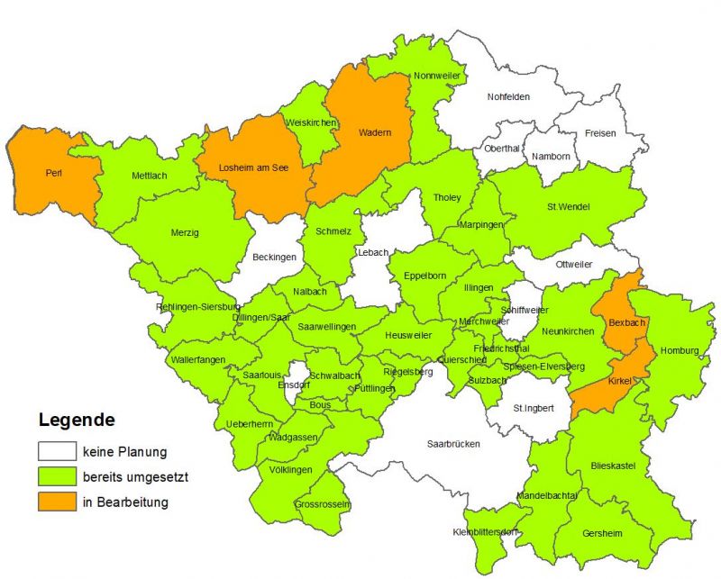
+ | <p>[[File:BPlaene Saarland 19 09 2025.jpg|alt=Zoning and land development plans from local authorities in Saarland|800px|link=]]</p> |
Aktuelle Version vom 15. Oktober 2025, 09:13 Uhr
Zoning/land development plans from local authorities in Saarland
A zoning plan sets out how much of what can be built where on a specific plot of land and is an important instrument for ensuring orderly urban development within a city or local government area (LGA).
The provisioning of municipal digital plans and articles is both supported and required by legislation at EU level, and by Saarland itself as a German land (INSPIRE Directive, SGDIG).
A dedicated application in GeoPortal Saarland facilitates the presentation of local authority zoning plans structured by district. Complementing the map view, users can also access and print out the wording of the decisions made as well as additional metadata.
As of this writing, full coverage is not available for all local authorities in Saarland (see figure). It is important to note that the data hosted in GeoPortal is not provided in an official or legal capacity and makes no claims to be exhaustive. Legally binding information is provided only by the approved original maps, which can be viewed at the city or local authority offices.
Alongside zoning plans, Geoportal Saarland can also display land development plans from local authorities as well as the plan from the Saarbrücken Regional Association.
Downloads
- Important note on legal validity of municipal plans (PDF)
- Guide to using the zoning plans provided on GeoPortal Saarland