Nationalpark Hunsrueck Hochwald/en: Unterschied zwischen den Versionen
Tschug (Diskussion | Beiträge) |
Tschug (Diskussion | Beiträge) |
||
| Zeile 25: | Zeile 25: | ||
<ul> |
<ul> |
||
| − | <li> |
+ | <li>the '''Act of Ratification for the State Charter between the States of Rhineland-Palatinate and Saarland Concerning the Creation and Maintenance of Hunsrück-Hochwald National Park'''</li> |
| − | <li>''' |
+ | <li>'''the State Charter between the States of Rhineland-Palatinate and Saarland Concerning the Creation and Maintenance of Hunsrück-Hochwald National Park'''</li> |
| − | <li> |
+ | <li>the '''topographic map''' and</li> |
| − | <li> |
+ | <li>the '''boundary map''' for the Hunsrück-Hochwald National Park</li> |
</ul> |
</ul> |
||
Version vom 24. März 2022, 07:45 Uhr
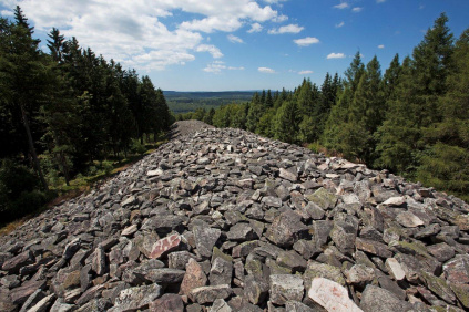
Hunsrück–Hochwald National Park in Rhineland-Palatinate and Saarland (February 2015)
Photo: K. Funk
Viewer
Go to map service ‘ Hunsrück-Hochwald National Park (Saarland section)’
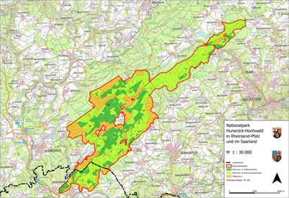
Go to map service ‘Hunsrück-Hochwald National Park (total area)’
Description
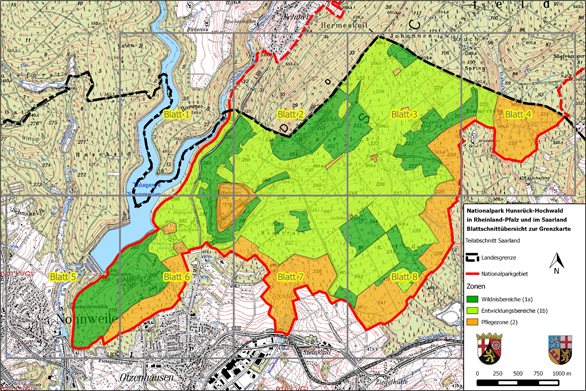
Rhineland-Palatinate and Saarland have signed a state charter to create a transboundary national park covering a total area of roughly 10,000 ha within the two states. The corresponding legislation was passed by the state parliaments of Saarland and Rhineland-Palatinate in late 2014/early 2015. Around 985 ha of the national park lies within the boundaries of the local government areas of Nohfelden and Nonnweiler. This region, which is located in Saarland, is shown on a topographic 1:10,000 scale map and a boundary 1:2,000 scale map (split over 8 sheets).
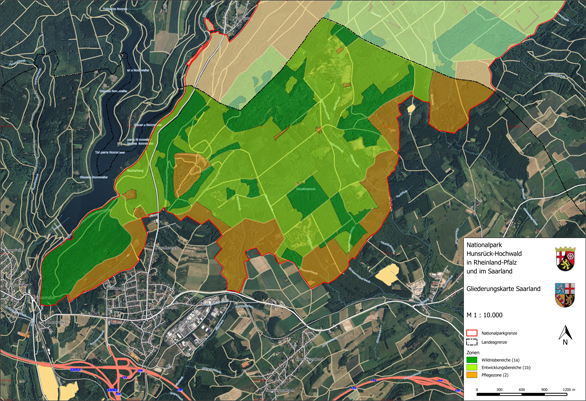
The thematic map shows the area that is valid for subsidiary protection as a national park in Saarland pursuant to section 24 of the Federal Conservation Act. This area is subdivided into the nature zone, consisting of nature zone 1a (untouched areas, dark green) and nature zone 1b (development areas, light green). This colour coding is intended to represent the varying level of man-made intervention in these two areas. In nature zone 1a (untouched areas), all forest management work has been discontinued and the forest has been left to its own devices. In nature zone 1b (development areas), the aim is to remove non-native species (and especially conifers) and thereby reconfigure the forest so that nature can take over and develop communities of forest species that are typical for the region. Overall, a maximum time frame of 30 years is allowed for nature zone 1b to develop into nature zone 1a.
Ultimately, nature zone 1a will then cover 75 percent of the park’s total area, so as to meet the IUCN’s international criteria for national parks. Nature will then be left to itself in this area.
The remaining area, making up 25 percent of the park, is assigned to buffer zone 2. This zone is intended to protect the nature zone against negative impacts from neighbouring territories. In this zone, upkeep and development measures can be carried out, which can also include supplying local populations with firewood, for example. Since the boundary map and the corresponding map service allow the identification of individual cadastral parcels, landowners can determine the exact extent – if any – to which they are affected by this project.
The boundary map and thematic map are fundamental to the creation of the Hunsrück-Hochwald National Park (Saarland section).
Relevant legislation for the Hunsrück-Hochwald National Park includes the following:
- the Act of Ratification for the State Charter between the States of Rhineland-Palatinate and Saarland Concerning the Creation and Maintenance of Hunsrück-Hochwald National Park
- the State Charter between the States of Rhineland-Palatinate and Saarland Concerning the Creation and Maintenance of Hunsrück-Hochwald National Park
- the topographic map and
- the boundary map for the Hunsrück-Hochwald National Park
Das saarländische Gesetz über die Zustimmung zu dem Staatsvertrag zwischen den Ländern Rheinland-Pfalz und Saarland über die Errichtung und Unterhaltung des Nationalparks Hunsrück-Hochwald kann hier ( Staatsvertrag) eingesehen werden.
Nationalpark Hunsrück-Hochwald
Der länderübergreifende Nationalpark Hunsrück-Hochwald bietet eine einmalige Natur – geprägt von alten Buchenwäldern, einsamen Mooren, lebendigem Totholz, steinigen Rosselhalden und bunten Arnikawiesen. "Natur Natur sein lassen" ist das Credo des Nationalparks. Gemeint ist damit das Zulassen natürlicher Prozesse, in die wir Menschen bewusst nicht gestaltend eingreifen. Die große Fläche eines Nationalparks gewährleistet diese Entwicklung.
Der saarländische Teil umfasst zwar nur 10 Prozent des gesamten Parks, aber der hat es in sich. Der keltische Ringwall ist in seinen Ausmaßen ein ganz besonderes Relikt unserer antiken Vorfahren und ein Publikumsmagnet für Besucher. Der Eisener Wald weist eine sehr hohe Naturschutzwürdigkeit aus und ist als Fauna-Flora-Habitat- und Vogelschutzgebiet Teil des europäischen Schutzgebietssystems Natura 2000.
Buchstäblich ins Auge fallen im Nationalpark drei herausragende Höhe(n)punkte:
- Der Erbeskopf als höchste Erhebung des Landes Rheinland-Pfalz mit den spannenden Angeboten rund um das Hunsrückhaus.
- Die Wildenburg mit ihren mystisch anmutenden Felsen und Wäldern sowie dem Wildfreigehege.
- Ringwall und Keltendorf im saarländischen Otzenhausen am Fuße des Dollbergs machen keltische Geschichte lebendig.
An drei Nationalpark-Toren (im Saarland: Keltenpark Otzenhausen) werden Besucher*innen empfangen und informiert.
Downloads
Gliederungskarte
Die Gliederungskarte liefert im Maßstab 1: 10.000 einen ersten Überblick über die Außengrenze und die innere Gliederung des Nationalparks Hunsrück-Hochwald.

Aus der Grenzkarte im Maßstab 1: 2.000 und dem entsprechenden Kartendienst können die jeweiligen Flurstücke hinsichtlich ihrer Lage im Nationalpark eindeutig verortet und identifiziert werden. Die Blattschnittübersicht soll die Orientierung erleichtern und einen geeigneten Suchhinweis liefern.
Blattschnittübersicht

Ansprechpartner
Ministerium für Umwelt und Verbraucherschutz
Referat D/3 "Landschaft, Fischerei und Umweltbildung"
Dr. Volker Wild
E-Mail-Kontakt
Telefon: +49 681 501-4747

