NGIS/en
National Spatial Information Strategy
Federal, state and local governments draw up a forward-looking and long-term spatial information policy
Ensuring basic data provision, simplifying multi-client use and promoting innovation are the three pillars of the National Spatial Information Strategy (NGIS).
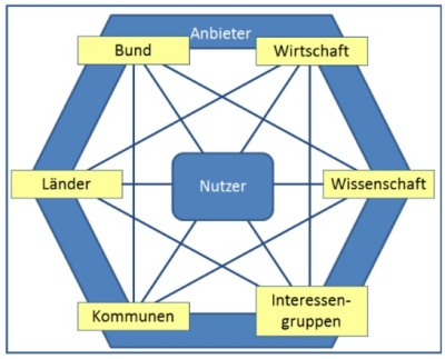
The NGIS is aimed at all stakeholders who collect, manage, provision or utilise spatial information. Spatial information should be effectively deployable for all decision-making processes, collected cost-effectively and to the fullest extent possible, and used to create value as a means of supporting national or local interests and fulfilling obligations. A shared basic understanding of strategic goals should also be achieved, while presenting an interpretation of own subject-specific tasks in a clear and transparent manner.
NGIS – content and implementation
Background
Spatial information forms the basis of many kinds of planning and decision-making work, and the actions that result from them. However, useful contexts are generally the result of combining a wide variety of spatial information from many different sources.
To ensure the future viability of spatial information as an important raw material for the digital society, one key ask presented in the 3rd Geospatial Progress Report from the German government was the development of a National Spatial Information Strategy (NGIS) containing the requirements for – and listing the benefits of – spatial information.
This was the reason why the GDI-DE Steering Committee developed the NGIS for Germany. The strategy was developed together with representatives from business and research, and included a wide-ranging public online participatory programme. The NGIS was adopted by the GDI-DE Steering Committee in autumn 2015. In the same year, the IT Planning Council identified the NGIS as an important supplement to the National E-Government Strategy (NEGS), further articulating the fundamental importance of the NGIS alongside GDI-DE for federal IT and e-government infrastructures.
Content
The NGIS is aimed at all stakeholders who collect, manage, provision or utilise spatial information. The overarching shared goal for federal, state and local governments is defined in the NGIS as follows.
Spatial information should meet the following criteria:
- Effectively deployable for all decision-making processes with a spatial component
- Collected cost-effectively and to the fullest extent possible
- Used to create value as a means of supporting national or local interests and fulfilling obligations
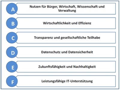
The NGIS also aims to achieve a shared basic understanding of strategic goals, while presenting an interpretation of own subject-specific tasks in a clear and transparent manner. The NGIS goals, which are organised into six goal categories totalling 15 goals and 47 subgoals, represent the situation aspired to – a mission statement, even – in relation to spatial information in Germany by the year 2025.
The NGIS also interprets the various roles to be adopted by the participating actors, since strategy implementation relies on these actors collectively tackling the workload together.
Implementation
In March 2016, the NGIS Implementation Working Group was set up to support the GDI-DE Steering Committee in its NGIS coordination and implementation work, and to ensure the long-term realisation and evaluation of the NGIS on the part of the GDI-DE Steering Committee.
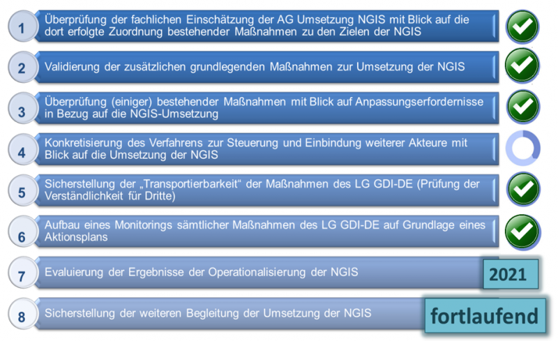
The Working Group was first commissioned with developing a model for operationalising the NGIS: this document was completed and accordingly adopted by the GDI-DE Steering Committee in 2017. The model paper includes fully-developed measures that are of fundamental importance for the achievement of specific goals. In most cases, it became clear that only minor adjustments to existing measures were necessary in order to ensure the achievement of NGIS goals.
In addition, other recommendations for action were defined for the GDI-DE Steering Committee in order to ensure the wide-ranging and long-term implementation of the NGIS. The implementation of these recommendations for action is managed and coordinated by the NGIS Implementation Working Group.
Since the implementation of the strategy is ultimately only achievable if the various actors collectively tackle the workload together, the NGIS Implementation Working Group is currently working on involving additional stakeholders. On the basis of a survey conducted in summer 2019 on NGIS activities on the part of federal and state governments, working group members were able to draw up recommendations for action to be applied at federal/state level in order to support NGIS implementation. The recommendations for action drawn up cover the specific activity, the actors addressed and the NGIS goals furthered by these actions. Another point of focus for the working group consisted of the interim evaluation of NGIS implementation results scheduled for 2021.
Downloads
Further information
Contact
Koodinierungsstelle GDI-DE beim Bundesamt für Kartographie und Geodäsie
Richard-Strauss-Allee 11
60598 Frankfurt am Main
E-Mail: mail@gdi-de.org
Phone: +49 69 6333-258
Fax: +49 69 6333-446